drawing, print, ink, pen, engraving
#
drawing
#
baroque
# print
#
pen illustration
#
pen sketch
#
landscape
#
ink
#
geometric
#
15_18th-century
#
pen
#
cityscape
#
engraving
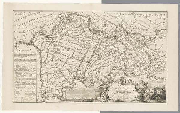
Dimensions: height 620 mm, width 703 mm
Copyright: Rijks Museum: Open Domain
Editor: This is a section of the "Kaart van de Tielerwaard," a map from 1759 created by Jan van Jagen, rendered in ink and engraving. Its level of detail is intriguing. I’m immediately struck by how meticulously the landscape is documented. What can you tell me about how this imagery speaks to its time? Curator: Notice the emphasis on geometric divisions, the clear delineation of property. This isn't merely a geographical document; it’s a statement about ownership and control. Each symbol, each line, resonates with the values of a land-holding society. The crests along the bottom further emphasize power. What emotions do those evoke in you? Editor: They definitely communicate status and history. Do you see other symbolism that is embedded within the map itself, beyond the heraldry? Curator: Certainly. The river, prominently featured, can be seen as a symbol of both life and division, a natural border but also a source of sustenance. The placement of towns – nodes of commerce and community – suggest the artist is reflecting not just what's on the land, but the very infrastructure of civilization. Even the careful script emphasizes order and legibility. Editor: So, the visual language tells a story of human attempts to tame and organize the natural world? Curator: Precisely! Consider how this contrasts with more romantic or picturesque landscape art of the period. It's less about the sublime and more about the surveyed. It privileges the pragmatic view of a world shaped by human intent. What impression does it leave you with about how the people viewed the land at that time? Editor: I hadn't considered the human intent shaping the work itself. Seeing it as a symbolic record of power rather than simply a depiction of geography makes me look at maps in a whole new light. Curator: It shows how symbols in art aren't always overt; sometimes they're embedded in the very act of representation.
Comments
No comments
Be the first to comment and join the conversation on the ultimate creative platform.
More like this