print, engraving
dutch-golden-age
pen sketch
landscape
geometric
engraving
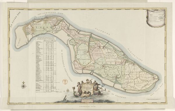
Dimensions: height 284 mm, width 375 mm
Copyright: Rijks Museum: Open Domain
This is Jacob van Meurs's copper engraving of the grietenij Het Bildt, which comes to us from the 17th century, a period of immense transformation in the Netherlands. This map isn't just a geographical document; it's a cultural artifact that speaks volumes about land ownership, agricultural practices, and the social hierarchy of the time. It was a period marked by land reclamation projects, transforming marshlands into arable land. Maps like these were not merely tools for navigation, they were instruments of power, defining territories and dictating resources. Notice how the details are meticulously rendered, reflecting a deep understanding of the local landscape. The presence of heraldic symbols and allegorical figures suggests the close ties between cartography and aristocratic patronage. It invites us to reflect on how such maps both shaped and mirrored the worldviews of their creators and their audiences. This work reminds us that maps are never neutral; they are always embedded with cultural and political meaning.
Comments
No comments
Be the first to comment and join the conversation on the ultimate creative platform.