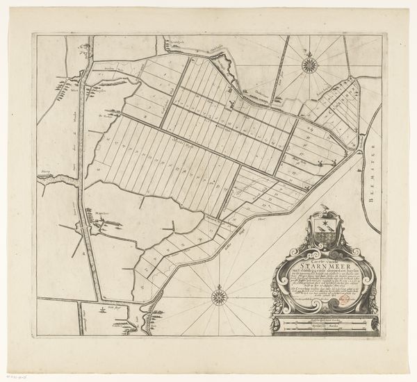
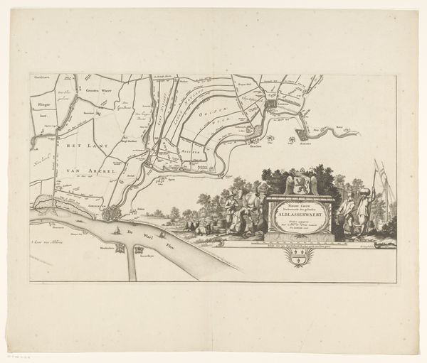
Kaart van de Zijpe- en Hazepolder (deel midden onder) 1665 - 1760
0:00
0:00
reiniervanpersijn
Rijksmuseum
#
quirky sketch
#
mechanical pen drawing
#
pen sketch
#
sketch book
#
personal sketchbook
#
sketchwork
#
pen-ink sketch
#
sketchbook drawing
#
storyboard and sketchbook work
#
sketchbook art
Dimensions: height 476 mm, width 545 mm
Copyright: Rijks Museum: Open Domain
Curator: This delicate pen drawing offers us a glimpse into the past: It's entitled "Kaart van de Zijpe- en Hazepolder (deel midden onder)," essentially a map of the Zijpe- and Hazepolder area, created sometime between 1665 and 1760. It's part of the Rijksmuseum's collection, attributed to Reinier van Persijn. Editor: My first impression is the stark contrast between the meticulous lines of the map and the rather whimsical vignette at the bottom left – cows, ornate scrolls, even a little cherub! It gives the whole thing a dreamlike quality. Curator: That's perceptive. These maps served not only practical purposes but also conveyed political authority. Including livestock and those cherubic flourishes also reinforced claims of ownership. Maps from this period show a burgeoning mercantile confidence. The details about the land were being meticulously recorded and this, in turn, helped facilitate investment, trade, and even conquest. Editor: Looking closer, the landscape divisions, labeled with letters, strike me as deeply symbolic. Beyond surveying boundaries, those repetitive patterns are almost totemic. Each section could represent something integral to their cultural or societal makeup, imbuing these agricultural fields with almost mythical qualities. The livestock grounds the whole thing to agriculture; they appear as a reminder of rural abundance that must have been ever-present on the creator’s mind. Curator: Absolutely. This wasn't just about recording what was there, but also what was valued. Notice how the towns, “S.Maarten” and “Schagen”, are rendered with a slightly different level of detail. That could be read as reflecting those community’s relative importance and standing in this landscape. How different districts may have been managed by different lords. Editor: It makes you wonder about the narratives woven into the land itself. This drawing, then, becomes a record of the area itself and a reminder of power dynamics at work, expressed through imagery that resonated with contemporaries. It's also like the creator saw something that we couldn’t appreciate at a distance—its importance to his livelihood. Curator: I find it so compelling how art of even mundane origins serves so beautifully as both artifact and insight. Editor: And I can feel that history made visible when seeing an old, simple, black and white sketch in full detail.
Comments
No comments
Be the first to comment and join the conversation on the ultimate creative platform.
More like this