graphic-art, print, engraving
#
graphic-art
#
16_19th-century
# print
#
asian-art
#
engraving
Dimensions: height 400 mm, width 535 mm
Copyright: Rijks Museum: Open Domain
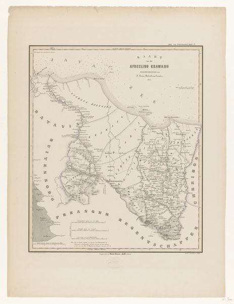
Curator: We're looking at a fascinating 1854 map created by F. Cronenberg, titled "Kaart van het regentschap en de stad Buitenzorg op Java," which translates to "Map of the Regency and City of Buitenzorg in Java." It's part of the Rijksmuseum's collection and is rendered as an engraving. Editor: The detail is remarkable. Even from a distance, the intricacy of the lines, the shading, it evokes a real sense of precision and order. It feels less like a purely informational document and more like a constructed vision of control. Curator: Exactly. The map is more than a simple representation; it's an assertion of Dutch colonial power in Java. The visual organization—how space is allocated, the prominence of certain areas—it all speaks to the colonial administration's priorities and how they visualized their control over the territory. Note how carefully cultivated regions contrast sharply with areas likely considered “unruly” or “untamed.” Editor: I'm also struck by the use of perspective. The elevation diagrams at the bottom, for example, suggest a scientific objectivity, but they simultaneously reinforce a sense of European dominance, framing the landscape from a detached, almost superior, point of view. And all that topographical data has a cool, detached feel. Curator: Indeed. The scientific gaze becomes a tool of governance. Furthermore, consider who would have commissioned and consumed such a map. Certainly, not the indigenous population, but rather Dutch administrators, plantation owners, and perhaps even those back in the Netherlands curious about their overseas holdings. Editor: Looking closer, I find the contrast between the fine linework representing infrastructure, and the slightly looser, almost romantic depiction of the landscape rather curious. It sets up a visual tension, maybe suggesting the uneasy relationship between imposition and integration? Curator: That’s an astute observation. The engraving technique itself, with its precise lines, mimics the desire for clarity and control characteristic of colonial endeavors. It suggests a level of imposed order, a narrative told from a very particular perspective. Editor: Overall, viewing Cronenberg's print, it brings to mind not just a geographical tool, but the layering of intention and vision inherent in even the most supposedly objective visual document. Curator: I agree completely. Examining such artworks reveals how cartography becomes a cultural project. Understanding this, we have a fuller, much richer, understanding of both its practical use, and profound societal effect.
Comments
No comments
Be the first to comment and join the conversation on the ultimate creative platform.
More like this