graphic-art, print, etching, engraving
#
graphic-art
#
dutch-golden-age
# print
#
etching
#
etching
#
cityscape
#
engraving
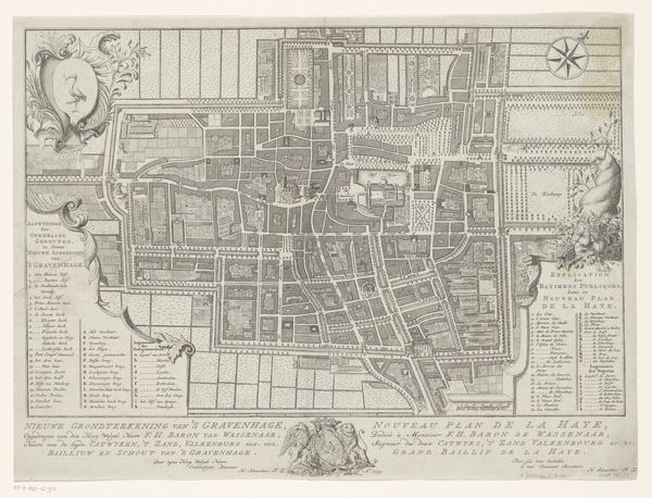
Dimensions: height 520 mm, width 585 mm
Copyright: Rijks Museum: Open Domain
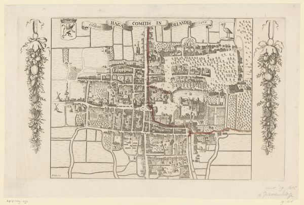
Editor: So this is "Plattegrond van Den Haag," a cityscape rendering of The Hague created sometime between 1815 and 1820. It’s a print, an engraving by Antoni Zürcher, hanging here at the Rijksmuseum. The detail is astonishing, so intricate! What really jumps out at me is how meticulously planned everything seems; almost rigid, with those straight lines carving up the space. How do you read this, beyond its practical function? Curator: Well, isn't it enchanting how maps become less about getting from A to B and more about portraying a city's soul? Zürcher's rendering breathes life into the streets and squares of The Hague. Beyond just lines and blocks, the print becomes a window into the mindset of the time. I find myself wondering, who commissioned this map, and what purpose did it truly serve? It's almost as if the act of mapping was a means of possessing, controlling, even celebrating the urban landscape. What thoughts arise for you, considering that idea? Editor: Control, that's interesting. It feels a bit…imposing, almost, even with the delicate lines. But, if you consider how cities are often symbols of power, a carefully crafted map like this makes a lot of sense. So, do you see this as more of a political statement then, than just a representation of a city? Curator: Political undercurrents are undoubtedly present, whispering from the neatly ordered structures. Yet, the map sings with a more personal melody as well. I mean, think about the engraver bent over their work, carefully etching each street, each building, leaving a mark, both artistic and historical. Don’t you find something poignant in that, this desire to capture and immortalize? Editor: Definitely! It is kind of amazing to think about someone dedicating that much time to capturing one specific place. Now I can't help but see it as this very deliberate act, not just of mapping but of preserving a moment. Curator: Exactly! So, now you also see echoes of ourselves, peering back from that moment captured, reminding us that cities, like art, are living, breathing testaments to human ambition and artistry.
Comments
No comments
Be the first to comment and join the conversation on the ultimate creative platform.
More like this