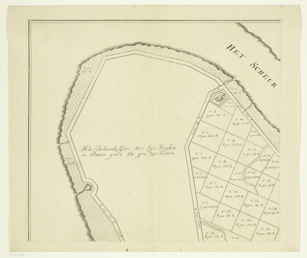
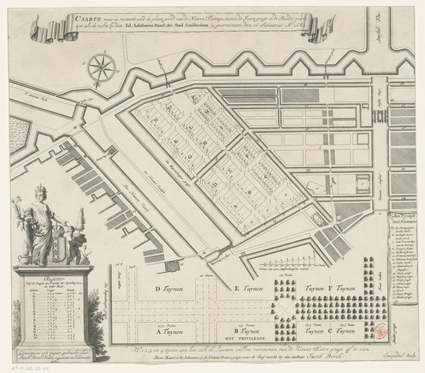
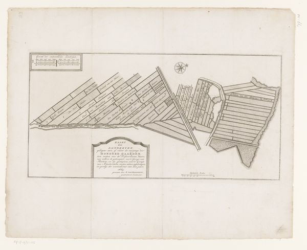
Plattegrond met de erven aan de Plantage Muidergracht en Nieuwe Keizersgracht Possibly 1727
0:00
0:00
drawing, print, architecture
#
architectural sketch
#
drawing
#
aged paper
#
dutch-golden-age
# print
#
old engraving style
#
architectural diagram
#
architectural plan
#
landscape
#
geometric
#
architectural section drawing
#
architectural drawing
#
architecture drawing
#
architectural proposal
#
cityscape
#
storyboard and sketchbook work
#
architecture
Dimensions: height 310 mm, width 378 mm
Copyright: Rijks Museum: Open Domain
Curator: We're looking at a drawing called "Plattegrond met de erven aan de Plantage Muidergracht en Nieuwe Keizersgracht," which roughly translates to "Map of the properties on the Plantage Muidergracht and Nieuwe Keizersgracht." It’s likely from 1727 and is attributed to an anonymous artist. Editor: Immediately, I'm struck by its geometric precision. The neat lines, the carefully measured plots—it speaks to a desire for order, control. It has the feel of something very considered. Curator: Absolutely. It’s a window into the urban planning and social structure of Amsterdam during the Dutch Golden Age. These plots represent land ownership, a source of power, privilege, and even social mobility in this period. Editor: Look at the rendering of the canals, so neatly presented. This interplay of land and water creates visual rhythm and delineates separate spaces. How do you read that formal decision? Curator: It's also important to acknowledge who is missing from this picture, while water management ensured wealth, the enslaved Africans in the Dutch colonies made much of this infrastructure possible through their forced labor. Editor: That point really highlights the complex histories inherent in what initially appears to be just a technical drawing. But look closer and notice that the scale seems to be represented visually as a bar in the very top portion of the map. That, again, drives home a focus on proportion and precision. Curator: These visual decisions serve to reify particular ways of thinking about property. Canals like those pictured are both tools and borders, the drawing thus displays both connection and division. Editor: Precisely. Focusing in on "’t Antonies Kerkhof," what assumptions, if any, do you think were being made by whomever decided how to render that specific burial location relative to surrounding land or infrastructural decisions? Curator: Given that mapping privileges those with land to mark as their own, to render such spaces with sensitivity allows us a more humane imagining of such fraught landscapes, both during the artwork's possible era and our own. Editor: Thanks for shedding new light on it! I see details now I wouldn't have noticed on my own. Curator: It's always rewarding to consider an image from both perspectives. They inform one another.
Comments
No comments
Be the first to comment and join the conversation on the ultimate creative platform.
More like this