drawing, paper, ink, pen
#
drawing
#
neoclacissism
#
aged paper
#
toned paper
#
sketch book
#
landscape
#
paper
#
personal sketchbook
#
ink
#
sketchwork
#
pen and pencil
#
sketchbook drawing
#
pen
#
watercolour illustration
#
storyboard and sketchbook work
#
sketchbook art
#
realism
Dimensions: height 278 mm, width 413 mm
Copyright: Rijks Museum: Open Domain
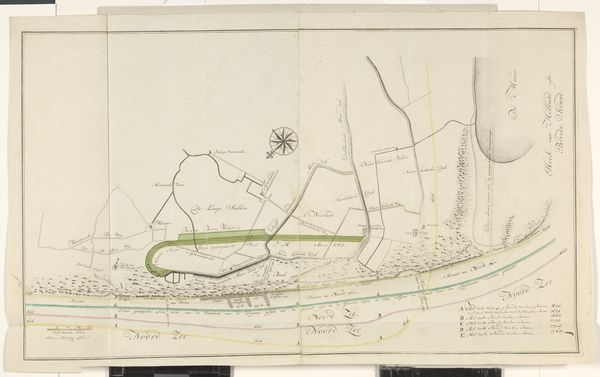
Curator: Standing before us is "Kaart van dijkdoorbraak onder Oosterhout, 1809", an ink and pen drawing on paper currently housed in the Rijksmuseum. What are your initial impressions? Editor: Stark. Austere. It's the meticulousness of the rendering against the backdrop of apparent chaos that strikes me. It looks like something made in the field under less than ideal circumstances. Curator: Indeed. Its creation speaks to a fascinating nexus of neoclassicism and realism. The meticulous detail suggests a scientific, objective approach, perfectly aligned with Neoclassical ideals of order and reason. Editor: I agree. I can see the precision of technique there. Yet the event it depicts is quite literally the shattering of order – a levee breach, devastating flooding. Do we know if this was produced *for* anyone or perhaps by an affected member of this society? Curator: The artist is currently listed as Anonymous but I agree with your implication: The composition directs our gaze—the eye traces the ruptured lines, the flooded plains—narrating a disruption. I can’t help but think about its scale and function. Note the legend provided—perhaps the work was produced for landowners in its direct aftermath. Editor: It makes one think about paper as a critical material here, as a means to rebuild in the abstract. Also, look at the evident weathering of the paper, its age. One has to wonder what processes and labors occurred there after the event, and of its impact. What about this work speaks to you, viewed through the lens of formalism? Curator: I'm drawn to the contrast between the sharp, deliberate linework defining structures versus the softer washes representing the flooded areas, creating depth and highlighting the impact of the disaster. Editor: Absolutely, the stark delineation is unforgettable. It is quite fascinating how this particular materiality creates an invitation for consideration of both the rupture and subsequent rebuilding through something so foundational as geographical redefinition on something as material as paper. Curator: Ultimately, whether seen as a study in Neoclassical order or as a document of material devastation, it remains a powerful image that lingers long after viewing. Editor: I agree; it invites considerations of social order, geographical place, and individual agency that continue to hold value today. Thank you.
Comments
No comments
Be the first to comment and join the conversation on the ultimate creative platform.
More like this