drawing, paper, ink
#
drawing
#
dutch-golden-age
#
pen sketch
#
landscape
#
paper
#
ink
#
geometric
#
line
#
cityscape
#
realism
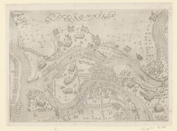
Dimensions: height 475 mm, width 717 mm
Copyright: Rijks Museum: Open Domain
This map of the Naardermeerpolder, crafted by an anonymous hand, likely involved ink on paper. Look closely, and you'll notice the gridded fields of the polder. These suggest an attempt to systematically organize and control the land for agricultural production. Maps like this weren't just about geography; they were tools of power and commerce. The very act of mapping implies ownership and the potential for exploitation. The fine lines and detailed inscriptions reveal a careful hand, skilled in both drafting and perhaps surveying. It's tempting to think about the labor involved, the hours spent rendering this landscape into a legible form. This wasn’t just about recording what was there, but about envisioning what could be: land transformed into a resource, a commodity. It’s a reminder that even seemingly straightforward images like this are deeply implicated in social and economic systems. By considering the map's materiality and purpose, we gain insight into the complex relationship between land, labor, and power.
Comments
No comments
Be the first to comment and join the conversation on the ultimate creative platform.
More like this