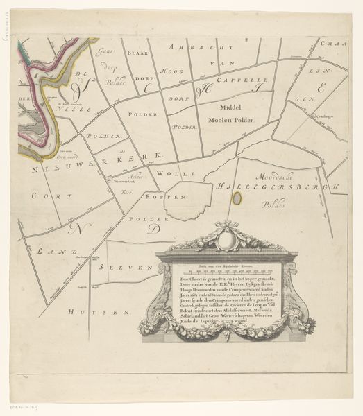
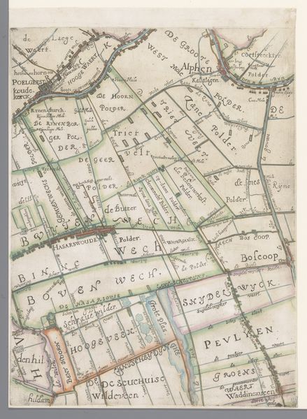
Kaart van het Hoogheemraadschap van de Krimpenerwaard (vierde deel van kaart) 1683 - 1741
0:00
0:00
johannesleupenius
Rijksmuseum
drawing, print, ink, engraving
#
architectural sketch
#
drawing
#
aged paper
#
mechanical pen drawing
# print
#
old engraving style
#
landscape
#
personal sketchbook
#
ink
#
sketchwork
#
pen-ink sketch
#
pen work
#
sketchbook drawing
#
cityscape
#
storyboard and sketchbook work
#
engraving
Dimensions: height 534 mm, width 532 mm
Copyright: Rijks Museum: Open Domain
Curator: Let's talk about this fascinating map, titled "Kaart van het Hoogheemraadschap van de Krimpenerwaard," a section of a larger work, actually. It was created sometime between 1683 and 1741 and is now held at the Rijksmuseum. The piece comes to us from the hand of Johannes Leupenius. Editor: Right away, it strikes me as incredibly precise, almost clinical. All those meticulously drawn lines separating the land. But, despite its precision, it has a strangely poetic feel. Maybe it's the faded quality of the paper, lending a wistful air? Curator: It is fascinating to consider the engraving as a document of both land and power. Every line dictates boundaries. We need to also appreciate the use of ink. Look how he manages to indicate depth with its variable strokes. Editor: True. The ink does give it character. Beyond its literal depiction of landscape, though, I see this image as a cultural artifact, speaking volumes about our human need to order and control the natural world. All those delineated plots hint at ownership, property rights... it's heavy with symbolic weight, isn’t it? Each name represents lineage, investment... Curator: Precisely. And also engineering. These polders--the Krimpenerwaard region is famously below sea level. So, the map is documenting the complex infrastructure. Every line signifies someone's land, someone's efforts against the rising tides. Editor: Knowing that context really deepens its impact. It transforms what I initially perceived as just a technical drawing into something that’s actually quite dramatic. Each little sector shows a continuous battle against what threatens it most. Curator: Exactly. Next time I see a plot of land, I want to try and think of its previous forms and conditions. And how humankind constantly has shaped them to his advantage. Editor: Yes. The map isn’t just about geography, is about aspiration, imposition, legacy... it all comes down to an understanding of continuous transition! Thanks for a mind opening introduction.
Comments
No comments
Be the first to comment and join the conversation on the ultimate creative platform.
More like this