drawing, print, etching, paper, engraving
#
drawing
#
dutch-golden-age
# print
#
etching
#
landscape
#
etching
#
paper
#
geometric
#
cityscape
#
engraving
Dimensions: height 457 mm, width 387 mm
Copyright: Rijks Museum: Open Domain
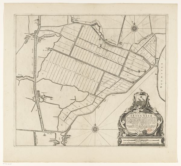
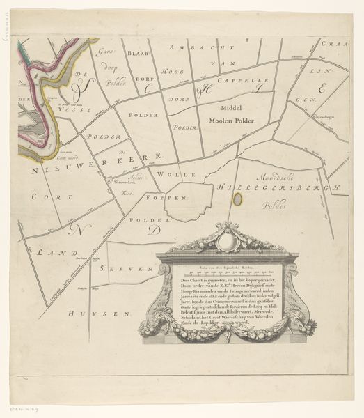
Curator: Right, let's talk about this fascinating fragment of an old map. This is a section of the "Kaart van de Beemster," by Daniël van Breen, dating somewhere between 1644 and 1721. It's a detailed etching, beautifully rendered on paper. Editor: Oh, yes! My immediate impression is that it feels like staring into a very orderly dream, doesn't it? All these crisp, precise lines. Like a carefully structured thought. But one filled with space for the imagination, a very flat imagination. Curator: Precisely! The linear precision is central. See how Van Breen uses geometric shapes to define the landscape. The grid-like structure speaks to the Dutch Golden Age's preoccupation with land reclamation and control over nature. The Beemster was one of the earliest polders, so maps were crucial to manage the territories. Editor: So, not only a picture, but almost an instruction manual. Still, for me, the text inside the cartouche stands out. Like a baroque window framing tiny thoughts. Curator: Indeed! The ornate cartouche offers context: it lists essential components like dikes, waterways, windmills. Its purpose goes beyond simple depiction, also. There is something to the concept of civic pride—almost of showing the benefits of the land. Editor: I like that. A demonstration in visual form, of a well planned society that also makes it legible and consumable by outsiders, for trading perhaps? Looking closely, even the way "De Zvyder Zee" curves at the bottom has this calming rhythm to it, doesn't it? Curator: Yes, absolutely. Van Breen wasn't merely recording geography; he was constructing a narrative of order, progress and... a certain kind of idealized landscape. It embodies the Dutch ambition. Editor: Mmh, well, it certainly invites us to contemplate how we visually represent and, indeed, control the natural world. Curator: Right. A landscape seen not just as something to inhabit but something to organize and own, depicted with careful intention, to demonstrate what humans did with it. Editor: Yes. And looking at that cartouche again makes me wonder how people would be proud of seeing such geometric plans depicted. A flat heaven made of mud. Anyway, it's quite captivating to experience this map from such a distanced viewpoint.
Comments
No comments
Be the first to comment and join the conversation on the ultimate creative platform.
More like this