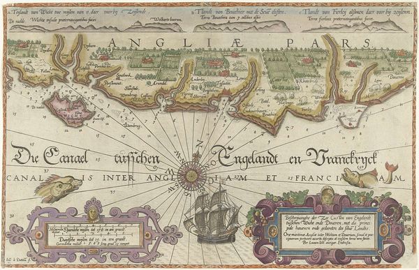
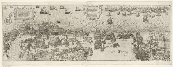
Kaart van de Zuidengelse kust tussen de Isle of Wight en Dover 1580 - 1583
0:00
0:00
joannesvanidoetechum
Rijksmuseum
drawing, print, paper, engraving
#
drawing
# print
#
landscape
#
paper
#
11_renaissance
#
history-painting
#
northern-renaissance
#
engraving
Dimensions: height 325 mm, width 508 mm
Copyright: Rijks Museum: Open Domain
Curator: This engraving and drawing on paper, crafted between 1580 and 1583 by Joannes van (I) Doetechum, presents a "Kaart van de Zuidengelse kust tussen de Isle of Wight en Dover," which translates to a map of the South English coast between the Isle of Wight and Dover. It’s currently housed in the Rijksmuseum. Editor: It's a fascinating composition. The pale hues and the careful arrangement of textual information suggest a sense of meticulous precision, but it also evokes a feeling of serene detachment, almost as if looking down from a great height upon this landscape. Curator: Indeed, the map possesses an undeniable compositional balance. Notice how the coastline is rendered with clear delineation, and consider how the upper band is neatly divided into geographical segments with towns indicated, allowing us to assess the organization of space during the Renaissance. The use of typography as a means of representing spatial and political understanding is evident. Editor: Looking at this work through a socio-political lens, maps weren’t just about geographic accuracy—they were tools of power, shaping narratives and control over territories. The map here doesn’t merely depict the coastline. It asserts ownership, highlighting the urban and natural resources while reinforcing the political narratives of that era. I am drawn to the ships at sea on the map that subtly reinforce narratives of empire and trade. Curator: Certainly, ships do reinforce trade dominance. Technically, the crosshatching indicates water, varying depth is rendered in light to dark ink. Semiotically, we read that darker portions are indeed deeper in volume. Scale too plays a crucial role. Though stylized and representational, the consistency of form in the houses in the rendering are successful. Editor: When looking at it that way, each element becomes a symbol within a visual language of that historical period. I'm particularly interested in what this map leaves out. Whose stories aren’t being told here? Are the rural communities, and labor divisions erased from such maps? Whose perspectives dominate cartography? It forces one to question the mapmaker's own position in the socio-economic sphere. Curator: These types of theoretical engagement certainly give a broader context when reading an image such as this map. From a purely formal approach, its enduring elegance in rendering geographical features as representational systems and spatial awareness provides compelling engagement. Editor: Maps are not just benign representations of territory, but tools of power and historical articulation. They allow us to deconstruct the past and re-examine its present consequences.
Comments
No comments
Be the first to comment and join the conversation on the ultimate creative platform.
More like this