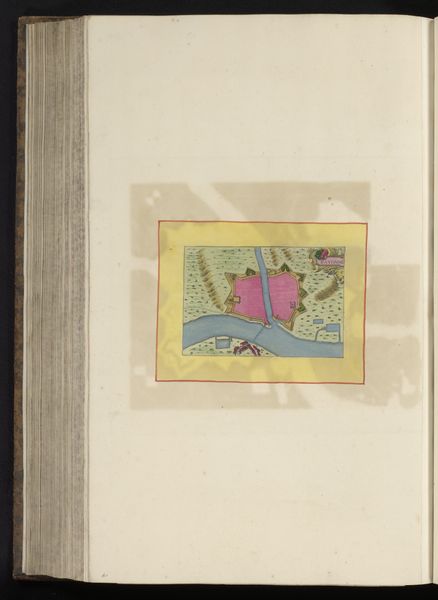
painting, print, watercolor
#
baroque
#
painting
# print
#
watercolor
#
cityscape
#
watercolor
Dimensions: height 105 mm, width 151 mm, height 532 mm, width 320 mm
Copyright: Rijks Museum: Open Domain
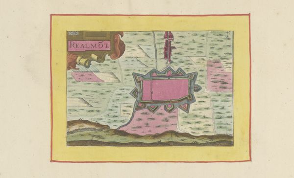
Curator: Alright, let’s dive into this fascinating, albeit peculiar, "Vestingplattegrond van Lectoure," created anonymously around 1638. It’s a print and watercolor work showcasing the town of Lectoure. What strikes you first? Editor: Hot pink! I mean, truly, a fortified town rendered in vibrant rose hues? It’s…unexpected. It feels like a Wes Anderson set design gone rogue. There’s something playful and almost rebellious about it. Curator: Well, before we fully surrender to whimsical interpretations, we should remember the socio-political function of such cityscapes. It isn't necessarily about aesthetics; it represents power and control. Look closely at the baroque detailing; these cartographies visually asserted territorial dominance. Editor: Oh, I get it. But still, the color! Perhaps this anonymous artist had a wicked sense of humor, or perhaps Lectoure was known for its impressive rose gardens...or rosé. One can dream. Look at how precise and organized it is—this piece had a specific purpose, perhaps intelligence-gathering. And notice how tiny the buildings are, compared with the large text in the upper right. Curator: Possibly both, who knows? These maps are rife with symbolism beyond pure practical depiction. The high vantage point flattens it; it transforms a space of life into something abstract, conquerable, which I find quite disconcerting. Editor: Precisely, it feels almost dehumanized, doesn’t it? Yet, those slightly blurred watercolor edges bring an element of vulnerability to it. It makes me question who was viewing this map. Was it a ruler secure in his castle or an advisor on a risky campaign? Curator: That very human element, that touch of ambiguity—I suppose it's why these prints endure. Editor: Indeed. It seems history always leaves space for speculation. A rosy reflection, wouldn't you say?
Comments
No comments
Be the first to comment and join the conversation on the ultimate creative platform.
More like this