print, engraving
#
baroque
# print
#
landscape
#
engraving
Dimensions: height 386 mm, width 514 mm
Copyright: Rijks Museum: Open Domain
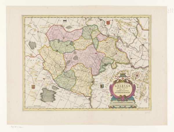
Curator: Let’s have a look at this print. It's an early map of the Nijmegen Quarter, titled "Kaart van het Kwartier van Nijmegen." Although attributed to an anonymous hand, we think it was made sometime between 1641 and 1711. It's an engraving. Editor: I immediately notice the stylized embellishments – the cartouche, the compass rose... it’s trying to be decorative as much as informative, almost like propaganda. And those colours marking different regions...what story are they trying to tell? Curator: Indeed. Map-making during this period was as much about asserting ownership and power as it was about geographic accuracy. The colors, for instance, would have demarcated territories and jurisdictions, key information for governance and military strategy. This quarter of Nijmegen was part of the Generality Lands, an area governed directly by the States General, where people of different belief systems, particularly Catholics, found a degree of autonomy compared to being subjected to city magistrates. Editor: So this isn't just lines on paper; it's about political identity, right? How did people navigate their identities in relation to these boundaries, these colored zones of power? Were there ever conflicts and disputes along these edges? Curator: Certainly. The placement and interpretation of such boundaries often sparked disagreements. For ordinary people, life would have been deeply connected to the rhythms of the land – agriculture, trade routes – but also shaped by where they stood in relation to these authorities and the rules and customs attached to these delineations. It speaks volumes to the era's socio-political dynamics, reflecting both power struggles and social accommodations. Editor: Thinking about our current times, what kind of impact do you think this visual language about who and what belongs where has, regarding conflicts and societal disputes in our present? Do these sorts of depictions subconsciously keep dividing people even nowadays? Curator: That's a profound point. Historical maps serve as both mirrors and prisms. While providing us glimpses into past landscapes, their implicit assertion of territories reminds us to be critically aware about historical impositions. What these meant in their era, how they have influenced people’s fate and how their subliminal power influences power structures in the current day is worth being investigated. Editor: It makes me think about the power of lines—both literal and figurative—and who draws them, who benefits, and who's excluded. These maps shape our understanding of the land and the politics enacted upon it.
Comments
No comments
Be the first to comment and join the conversation on the ultimate creative platform.
More like this