print, etching, engraving
baroque
etching
linocut print
cityscape
engraving
Dimensions: height 470 mm, width 367 mm
Copyright: Rijks Museum: Open Domain
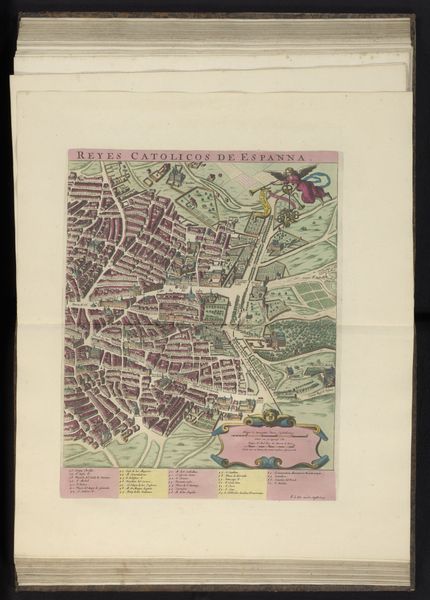
Curator: This etching and engraving offers a glimpse into Madrid between 1640 and 1706. It's attributed to an anonymous artist and is currently held in the Rijksmuseum's collection, titled "Plattegrond van Madrid, linkerdeel", which translates to "Map of Madrid, left part." Editor: The initial impression is quite intricate! There’s a sense of controlled chaos. It feels very architectural, geometric, but softened by the almost pastel hues of color. It reminds me a bit of textile design, really. Curator: Indeed. Consider how prints like this were distributed. They served practical purposes—wayfinding, city planning—but also political ones. Mapmaking was often tied to asserting power, controlling territory. Etching and engraving allowed for mass production of this imagery. Editor: Precisely, it's fascinating to observe the interplay between function and form. The density of the urban space on the right sharply contrasts with the more open areas near the river on the left. It establishes visual interest but also guides your understanding of how people used the city and its resources. And did they apply colors by hand to each print, I wonder, thus rendering each version a kind of limited edition in its own right? Curator: The color application methods employed in such prints varied. Hand-coloring was common, yes, although stencils could sometimes speed the process. That said, thinking about this object within its broader socio-economic context invites questions. What class of person owned this? Did increased trade render certain districts more prominent, necessitating mapping updates, do you think? These concerns relate production directly to societal needs. Editor: Absolutely. By looking closely, you note how its forms aren't arbitrary, and it shows conscious arrangement. What do you think this image reveals about the cultural values placed on spatial representation at that moment in history? Curator: It provides a very formalized idea of space and place, definitely; something very different from how we experience cities today. These visual tools reflect evolving social needs, which makes a supposedly anonymous work actually deeply resonant and representative of the community that brought it into being. Editor: In short, analyzing this "Map of Madrid" allows us to contemplate design principles as reflective of their age.
Comments
No comments
Be the first to comment and join the conversation on the ultimate creative platform.