drawing, print, paper, ink, engraving
#
drawing
#
dutch-golden-age
# print
#
landscape
#
paper
#
ink
#
geometric
#
line
#
cityscape
#
academic-art
#
engraving
Dimensions: height 147 mm, width 227 mm
Copyright: Rijks Museum: Open Domain
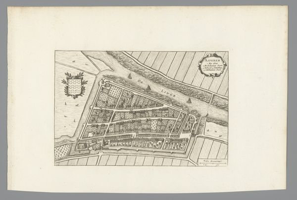
Curator: Welcome. We're looking at an early 17th-century engraving, titled "Plattegrond van Goedereede," dating back to 1632. It is currently held at the Rijksmuseum. Editor: At first glance, the intricate linework draws me in; there is something strangely appealing about seeing the landscape laid out in this precise, almost sterile manner. Curator: These Dutch Golden Age maps weren't simply geographic tools; they represented power and control, a burgeoning understanding of the world that directly fed into the commercial ambitions of the Dutch Republic. This specific plattegrond, or plan, offers a bird’s-eye view of the town, depicting land divisions and maritime elements such as sailing vessels. Editor: Thinking about contemporary mapping technologies, and their increasing applications in surveillance, urban planning and even real estate, the cartographic representation of a place is not apolitical. Do we know about this specific artwork's purpose and who the intended audience was? Curator: Likely wealthy merchants, navigators or government officials involved in trade and defense. Consider Goedereede's location; access to waterways was imperative during the Dutch Golden Age and the establishment of Dutch trading routes. It is key to situate such an artifact as this in broader historical narratives of global resource extraction and colonialism. Editor: Exactly. I am also stuck on the lines used to demarcate territory, because for the people who were written out of that cartography, its aesthetic appeal surely diminishes. In the end, such aesthetics also serve to conceal power structures. The scale and materials—ink on paper—emphasize the map's function, it would be relatively easy to reproduce and disseminate. Curator: True. The geometric precision gives a false sense of neutrality to something inherently embedded in political and economic structures. I believe interrogating that assumed neutrality becomes crucial to dismantling existing hierarchies. Editor: A seemingly simple town plan really reveals itself to be much more than that. Curator: It underlines how profoundly representations are linked to social power dynamics. That alone allows this item to stay so poignant, centuries later.
Comments
No comments
Be the first to comment and join the conversation on the ultimate creative platform.
More like this