drawing, print, watercolor
#
drawing
#
water colours
#
baroque
#
ink paper printed
# print
#
watercolor
#
coloured pencil
#
cityscape
#
watercolor
Dimensions: height 122 mm, width 174 mm
Copyright: Rijks Museum: Open Domain
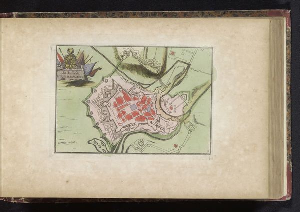
Curator: Let's turn our attention to this charming depiction of London. Known as "Plattegrond van Londen," it dates back to 1735 and presents a baroque vision of the city. Editor: What strikes me immediately is the delicate rendering. The watercolors give it such a soft, almost dreamlike quality, like looking at a memory. And the intense, orangey-red is fascinating. Curator: Indeed. Its creation is especially interesting because cityscapes like this became increasingly popular in the 18th century, reflecting the growing interest in urban planning and civic identity. The very act of mapping, of defining spaces, became a powerful expression of control and understanding. Editor: So, it's not just about showing where things are, but also making a statement? You're implying that representing urban environments like this says more about a society than one would first realize, that it acts a signifier to power and privilege? Curator: Precisely. London at the time was a hub of trade, political maneuvering, and cultural development. Depicting it visually reinforces its perceived importance in a global network and creates an ideal, perhaps even propagandistic view for consumption, almost creating a symbolic ownership through art. Editor: Right, a controlled version. Thinking of what lies beneath the veneer makes me question its function. There’s that lovely, ornate river snaking through… was it a symbol of purity and a bustling city? Now, what about the invisible London represented in this image? Curator: Certainly. There are tensions: London was marked with poverty, inequality and disease in the 18th Century. That reality of what lies beneath this drawing could well clash with its clean aesthetic and purpose of design. Editor: And maybe that’s what draws me to it: that subtle tension between what's shown and what isn't. All of art history considered, the relationship between social reality, artist intention and final output makes any encounter truly unique. It’s nice to muse and feel, knowing that these artefacts allow us this window in time and insight.
Comments
No comments
Be the first to comment and join the conversation on the ultimate creative platform.
More like this