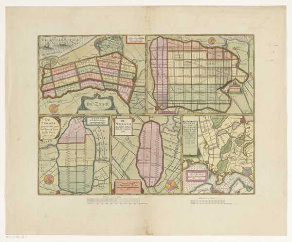
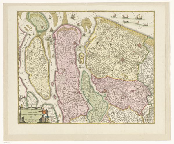
Blad met kaarten van de polders van de Zijpe, Beemster, Purmer, Wormer en een kaart van Waterland 1631 - 1638
0:00
0:00
pietervanderkeere
Rijksmuseum
print, paper, engraving
#
dutch-golden-age
#
ink paper printed
# print
#
landscape
#
paper
#
geometric
#
engraving
Dimensions: height 348 mm, width 474 mm
Copyright: Rijks Museum: Open Domain
Editor: This is a fascinating print dating back to between 1631 and 1638. It's titled "Blad met kaarten van de polders van de Zijpe, Beemster, Purmer, Wormer en een kaart van Waterland" made by Pieter van der Keere. It’s a detailed composite map of several polders in the Netherlands, crafted with ink on paper through engraving. The neat geometric precision is quite striking...it almost doesn't feel like art at all, but engineering! What catches your eye? Curator: Oh, the rigid beauty of reclamation, it's breathtaking, isn’t it? Look closely at the stark lines. Do you sense the *tension* between human ambition and nature's pushback? Van der Keere gives us more than just a map, doesn't he? I feel he's captured the very soul of the Dutch Golden Age; a blend of ingenuity, exploration, and maybe even a touch of defiance against the sea. These weren't just places on a map, but living, breathing economic engines for the Dutch. What kind of stories can you conjure, seeing this print? Editor: Stories of windmills, endless fields, and maybe even hidden treasures? The colors too, a bit faded, but with those touches of pale pinks and yellows – does that have some significance? Curator: Colors certainly played a role! Back then, hand-coloring prints was common and could denote land ownership, soil types, or administrative boundaries. Imagine, someone painstakingly adding colour, brining order – almost an owner's manual! I bet each family invested in one. What do you think the original intent was, viewing all of this through a modern eye? Editor: That's true, the original context of displaying information could be artistic! Looking at the organization, and reflecting on your points about Golden Age ambition makes it clear how much this era valued order and reason. I am not just looking at a map but an ideology on display. Thank you for the new way to see art. Curator: My pleasure! And look closely! In this blend of precision and imagination lies a reflection of us all – our yearning to master our environment while respecting its boundaries, an on-going push and pull to this day.
Comments
No comments
Be the first to comment and join the conversation on the ultimate creative platform.
More like this