print, etching, engraving
# print
#
etching
#
landscape
#
etching
#
engraving
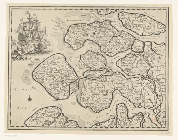
Dimensions: height 497 mm, width 609 mm
Copyright: Rijks Museum: Open Domain
Editor: This is "Kaart van Zeeland," a map of Zeeland from 1785. It's an etching and engraving, with faded colors. I'm struck by how much detail is crammed into this small area. It feels like so much more than just a geographic record. What do you see in this piece? Curator: I see a world caught between precision and poetry. Maps are inherently symbolic – claiming territory, defining boundaries. Notice how the cartographer highlights not just landmass but also the waterways. What emotions do the watery arteries evoke in you? Editor: Well, the sea connects everything but also suggests vulnerability, doesn't it? Thinking about the Dutch relationship with the sea, constantly battling it… Curator: Precisely! Consider the net-like emblem in the corner, almost a trophy. It represents mastery over nature, but there’s a tension. The sea also offers life and commerce, an intricate balance. Do you feel that tension embodied anywhere else in the image? Editor: Maybe in how everything is labelled so carefully but also artistically? It’s informative but also beautiful. The words are little symbols themselves, holding history within them. Curator: Yes! Each place name is like a memory anchor. They remind us that this isn't just a picture; it is a cultural palimpsest layered with human experience. These symbols both create and contain power. Editor: So, the map is an image that's meant to convey practical information but also embedded with meaning. It is a lot more than a simple directory. Curator: Indeed. And by understanding those layers, we understand something deeper about Zeeland’s history and its place in the world.
Comments
No comments
Be the first to comment and join the conversation on the ultimate creative platform.
More like this