print, engraving
#
baroque
# print
#
landscape
#
history-painting
#
engraving
Dimensions: height 635 mm, width 511 mm
Copyright: Rijks Museum: Open Domain
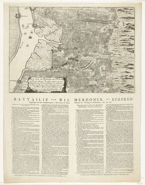
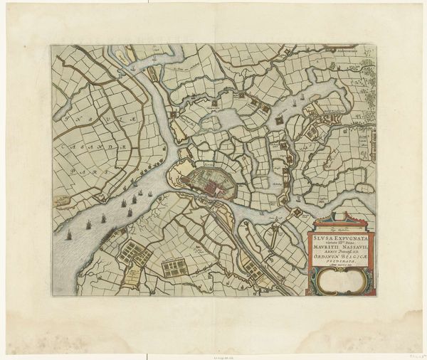
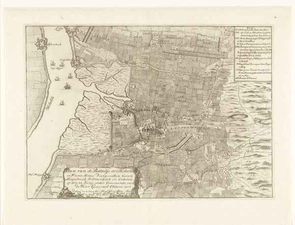
Curator: This print, created anonymously in 1703, is entitled "Kaart van de veldslag bij Ekeren, 1703", which translates to "Map of the Battle of Ekeren." It’s held at the Rijksmuseum. Editor: Immediately striking. It looks so measured, so calm... but it's a depiction of a battlefield! The detailed neatness almost feels like a sanitization of conflict. Curator: Precisely! The piece showcases a clash between the Dutch and Franco-Spanish forces. The method of engraving and its dissemination as a print would have allowed for fairly widespread viewing. Think of the labor involved in creating such a meticulously detailed map. The physical process of carving these details into a plate! Editor: I'm fascinated by the way the landscape becomes a theater of war, almost an actor itself. The river Scheldt for example is present and is adorned with ships and fortified with a star fort on the left. Curator: Indeed. Note how the cultivated lands, carefully divided and seemingly orderly, suddenly become fragmented and disrupted by the presence of military emplacements. It speaks to how the landscape's function is fundamentally altered by the war effort, highlighting the means through which war consumes resources. Editor: It’s the little visual anchors for me. The clusters of buildings represent human lives and their destruction. It reminds us that strategy and territory involve far more than lines on a map. There are stories and experiences tied into it. Curator: The scale here matters. While displaying tactical information, such as troop movements and defensive structures, the engraving technique is crucial, making multiple copies available to analyze and understand this battle on paper, reflecting broader availability of printed materials at the time. The printing of maps such as this enabled a kind of armchair strategizing and, therefore, participation. Editor: So true! I’ve spent some time lost in that detail, pondering how cartography helps give a semblance of order to the messy business of human conflict, of what it meant to process and understand that battle. Curator: Absolutely. We often divorce conflict from the means through which we represent conflict. What looks like an organized map involved incredible resources and craft, as well as an exercise of power in shaping narratives of conflict. Editor: A poignant insight that lingers now I consider how symbols outlive those battles they represent.
Comments
No comments
Be the first to comment and join the conversation on the ultimate creative platform.
More like this