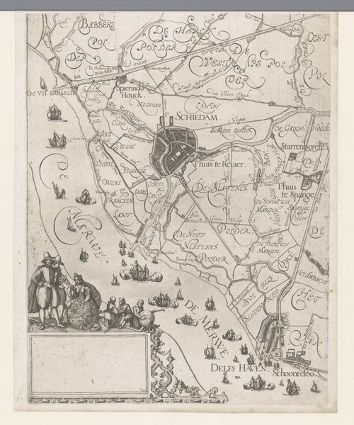
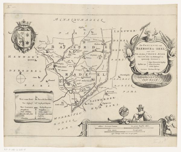
Kaart van het Hoogheemraadschap van Delfland, met Schiedam en omgeving, deel rechtsonder 1611 - 1692
0:00
0:00
florisbalthasarszvanberckenrode
Rijksmuseum
print, engraving
#
dutch-golden-age
# print
#
old engraving style
#
landscape
#
geometric
#
cityscape
#
decorative-art
#
engraving
Dimensions: height 383 mm, width 301 mm
Copyright: Rijks Museum: Open Domain
Curator: This engraving presents part of Floris Balthasarsz van Berckenrode’s "Map of the Delfland Water Board, with Schiedam and surroundings," dating roughly from 1611 to 1692. Editor: My first impression is that it's an aesthetic fusion of function and fantasy. The detail is mesmerizing, but then the flourish along the coast turns almost allegorical. Curator: It's fascinating how these early maps were so much more than just geographic representations. They carried cultural weight, embodying a community’s sense of place and its relationship to the land and sea. Notice the inclusion of figures along the Merwe River? Editor: Precisely! Their placement shifts the work from a purely objective document into something symbolic, imbued with human narrative and possibly even acting as some sort of cultural mnemonic. It seems concerned with order, but simultaneously infused with dynamic, almost baroque sensibilities. The ornate flourishes borderlines the map's otherwise rational presentation of space. Curator: Indeed, the embellishments contribute a layer of visual richness that would resonate with viewers of that period. Ships are depicted, tiny yet potent symbols of trade, exploration, and the dominance over waterways. Even the font itself communicates authority and establishment. Editor: And look at how space is segmented, creating clear boundaries within the territory through carefully drawn lines. Even without prior understanding, you can discern visual logic, reflecting perhaps a deeper cognitive understanding of this landscape that prioritizes systematization and categorisation. Curator: Absolutely. And don’t forget that maintaining these waterways was critical for defense, transportation, and agriculture in the Netherlands. A map like this was likely seen as a tool of governance, solidifying claims and delineating responsibilities. These geometric polders must have represented progress and technological triumph. Editor: The visual rhythm created through the arrangement of textual annotations and the stylized depictions also invites continuous engagement, almost as if the image is prompting the user to unravel the history written between these delicate linework. I do find myself wanting to understand the placement of each small village along these byways. Curator: Reflecting on this piece, I’m reminded of how maps shape not just our physical understanding but also our shared cultural memory. Editor: And for me, it underscores the importance of questioning what’s presented as objective, acknowledging the artistry that underlies even the most practical tools.
Comments
No comments
Be the first to comment and join the conversation on the ultimate creative platform.
More like this