About this artwork
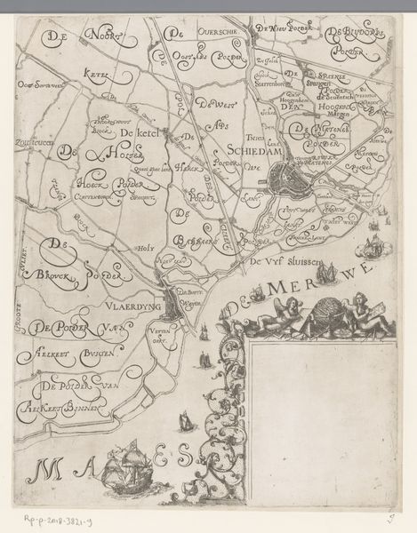
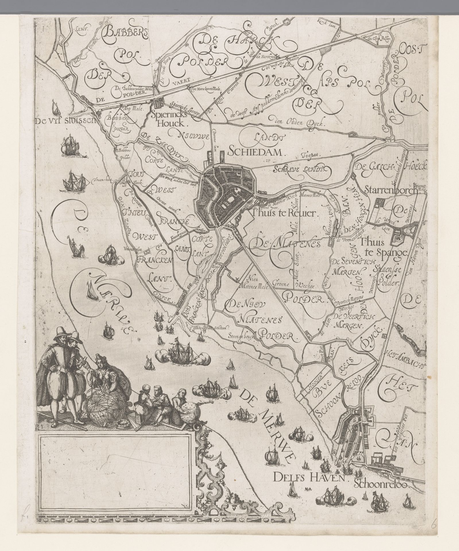
Editor: We’re looking at “Kaart van het Hoogheemraadschap van Schieland, met Schiedam en Delfshaven,” a map of the Schieland district with Schiedam and Delfshaven, made between 1611 and 1635 by Floris Balthasarsz van Berckenrode. It’s an engraved print. The detail is striking, but it also feels like it presents a very controlled, almost...colonized, view of the landscape. How do you interpret this work? Curator: That’s a really insightful initial reaction. It’s crucial to remember the Netherlands' global power during this period. Mapping wasn't just about geographical accuracy, it was an act of asserting control and visualizing resources for economic and political gain. Look at the placement of Delfshaven, its proximity to the sea; it was a major port. How does that relationship strike you within the larger context of Dutch maritime power? Editor: I see it. It’s almost like Delfshaven is positioned as a gateway, a point of access to global trade and influence. The figures in the corner also strike me, could these figures allude to class hierarchies inherent to the society represented here? Curator: Exactly. Notice how they are carefully placed and how their activity suggests economic exchange and management. The map highlights not only spatial organization but also the social hierarchy that benefited from this engineered landscape. The Dutch Golden Age wasn’t golden for everyone. Whose labor enabled this "controlled" landscape you mentioned? Editor: So, it's not just a picture of a place, but a statement about power, trade, and societal structures. Understanding it requires thinking about the people who lived and worked in this landscape, not just those who profited from it. Curator: Precisely. Maps are never neutral; they're always telling a story from a particular perspective, usually that of the powerful. Hopefully now, you will look at all maps a little differently from here on out. Editor: Absolutely! It definitely offers a richer, more critical way to understand historical images.
Kaart van het Hoogheemraadschap van Schieland, met Schiedam en Delfshaven
1611 - 1635
Floris Balthasarsz van Berckenrode
1562 - 1616Location
RijksmuseumArtwork details
- Medium
- print, engraving
- Dimensions
- height 378 mm, width 293 mm
- Location
- Rijksmuseum
- Copyright
- Rijks Museum: Open Domain
Tags
dutch-golden-age
landscape
cityscape
engraving
Comments
Be the first to share your thoughts about this work.
About this artwork
Editor: We’re looking at “Kaart van het Hoogheemraadschap van Schieland, met Schiedam en Delfshaven,” a map of the Schieland district with Schiedam and Delfshaven, made between 1611 and 1635 by Floris Balthasarsz van Berckenrode. It’s an engraved print. The detail is striking, but it also feels like it presents a very controlled, almost...colonized, view of the landscape. How do you interpret this work? Curator: That’s a really insightful initial reaction. It’s crucial to remember the Netherlands' global power during this period. Mapping wasn't just about geographical accuracy, it was an act of asserting control and visualizing resources for economic and political gain. Look at the placement of Delfshaven, its proximity to the sea; it was a major port. How does that relationship strike you within the larger context of Dutch maritime power? Editor: I see it. It’s almost like Delfshaven is positioned as a gateway, a point of access to global trade and influence. The figures in the corner also strike me, could these figures allude to class hierarchies inherent to the society represented here? Curator: Exactly. Notice how they are carefully placed and how their activity suggests economic exchange and management. The map highlights not only spatial organization but also the social hierarchy that benefited from this engineered landscape. The Dutch Golden Age wasn’t golden for everyone. Whose labor enabled this "controlled" landscape you mentioned? Editor: So, it's not just a picture of a place, but a statement about power, trade, and societal structures. Understanding it requires thinking about the people who lived and worked in this landscape, not just those who profited from it. Curator: Precisely. Maps are never neutral; they're always telling a story from a particular perspective, usually that of the powerful. Hopefully now, you will look at all maps a little differently from here on out. Editor: Absolutely! It definitely offers a richer, more critical way to understand historical images.
Comments
Be the first to share your thoughts about this work.