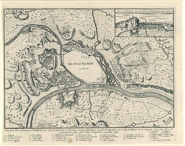
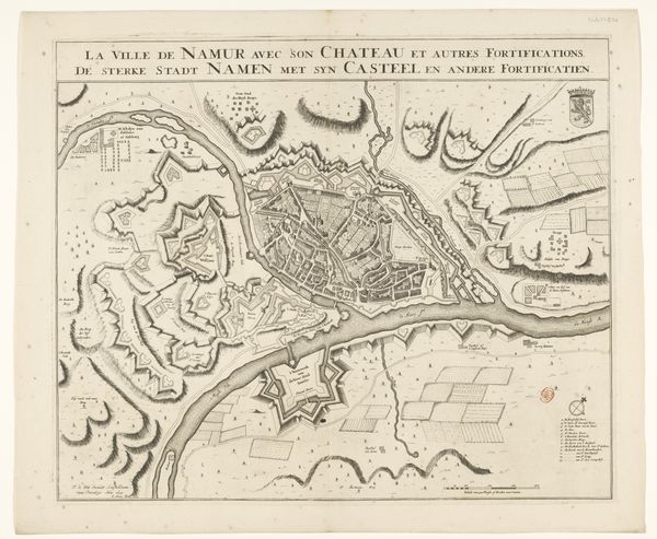
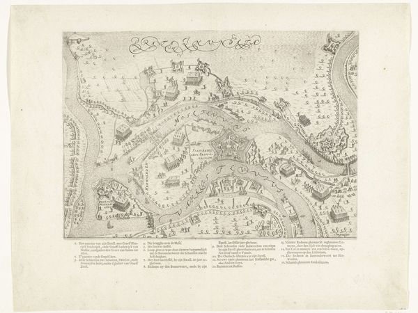
Ingekleurde kaart van de versterkingen van Namen bij het beleg in 1695 1695
0:00
0:00
anonymous
Rijksmuseum
print, engraving
#
baroque
# print
#
cityscape
#
history-painting
#
engraving
Dimensions: height 483 mm, width 622 mm
Copyright: Rijks Museum: Open Domain
Curator: Here we have an engraved and hand-colored print dating back to 1695, now in the Rijksmuseum collection: "Ingekleurde kaart van de versterkingen van Namen bij het beleg in 1695," depicting the siege of Namur. It's attributed to an anonymous artist. Editor: Immediately, I notice the level of intricate detail – a veritable cartographic obsession. The coloring seems purposefully muted, lending a rather melancholic air despite the chaotic subject matter of a city under siege. Curator: Yes, the print highlights the material concerns of siege warfare during the late 17th century. Look at how each fortification, each battery placement, and indeed, each unit of soldiers is painstakingly represented. This level of detail speaks to a culture deeply concerned with the logistics and engineering of power. Editor: And yet, the very choice of an elevated, almost bird's-eye perspective serves to remove us emotionally. We’re distanced, observers to the unfolding drama below. There's a strange beauty, even in the depiction of such a destructive event. Consider, for example, how the city itself – "La Ville," it is labelled – rests placidly amid swirling chaos, a powerful symbol of resilience. Curator: I see the visual hierarchy at play. The cartographer meticulously etches the means of prosecuting the siege—trenches, emplacements, cannon—showing labor in warfare. Resources expended during war have become almost ritualistic in their production here as lines cut and formed a symbolic power for military use. Editor: It certainly underscores the significance of Namur as a strategic location. Waterways snake around it. The lower corner reveals an allegorical tableau. Notice how they rendered it from a human viewpoint in opposition to a generalized war from above? The print as a whole becomes more than documentation. Instead, a story emerges about conflict that transforms landscapes. Curator: Exactly, these types of images show power and ownership being mapped literally across geographic areas but also how the production is inherently involved in class, military might, labor conditions, materials access and costs incurred throughout warfare as represented for potential consumers or rulers observing afar this siege as it occurred centuries ago through our perspectives today! Editor: Well put. By bringing together historical narrative and iconic visual encoding, the image achieves an emotional resonance that surpasses simple reportage of fact. Ultimately, in a curious act of observation, we gain new insights into that siege.
Comments
No comments
Be the first to comment and join the conversation on the ultimate creative platform.
More like this