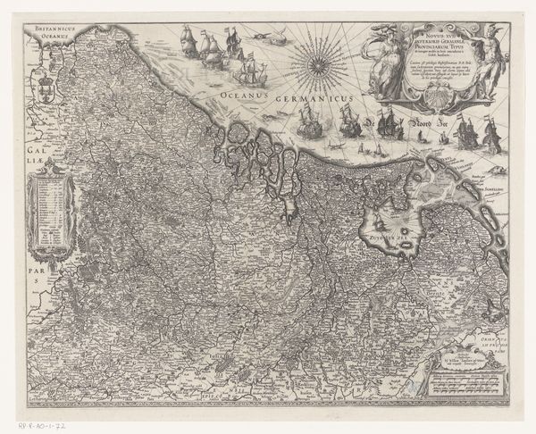
Middelste deel van een driedelige zeekaart van de Middellandse Zee 1694 - 1700
0:00
0:00
romeyndehooghe
Rijksmuseum
graphic-art, print, engraving
#
graphic-art
#
baroque
# print
#
landscape
#
cityscape
#
engraving
Dimensions: height 601 mm, width 481 mm
Copyright: Rijks Museum: Open Domain
Curator: This detailed engraving, entitled "Middle Part of a Three-Part Sea Chart of the Mediterranean Sea," comes to us from Romeyn de Hooghe, dating roughly from 1694 to 1700. Editor: It has a rather somber yet precise affect—almost architectural in its intricacy. The shading gives it depth. One can’t help but immediately think about colonial expansions, looking at it today. Curator: Absolutely. The detailed rendering really exemplifies Baroque aesthetics. Observe how de Hooghe balances practical cartography with artistic flair. Note the radiating lines, seemingly scientific, projecting from strategic points, contrasted with illustrative cityscapes that border the map. Editor: I see the radial lines as evidence of how geography during the period literally radiated from certain important centres as places of mercantile power, enabling further violence and extraction. What is also interesting is how figures are added decoratively. Who exactly did these maps serve, what interests did they protect? Curator: One can appreciate the composition from another perspective: consider how the carefully placed vignettes displaying views of Marseilles, Genoa and Venice enhance the piece as a whole. Editor: But even in these picturesque depictions of these grand old trade capitals, we must understand that, just as these old empires were creating aesthetic self-portraits, they were involved in activities which harmed vulnerable others. What do you feel about that context and the effect that these types of aesthetic depictions and seemingly objective renderings have in legitimising certain forms of authority? Curator: Of course, context matters, but it would be a mistake not to acknowledge that it's an exquisite example of engraving technique and the historical desire to map and order the world. Let's focus, too, on its aesthetic construction and material achievement. Editor: Indeed, technique should always be seen as linked to how we interpret context; this piece provides a fascinating glimpse into that dialogue between form and socio-political forces at play. Curator: Indeed. Hopefully visitors will leave with a greater appreciation for the various levels of information and skill woven into this impressive maritime cartography.
Comments
No comments
Be the first to comment and join the conversation on the ultimate creative platform.
More like this