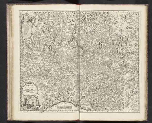
Kaart van het strijdtoneel in Piemonte en Savoye, ca. 1688-1697 1685 - 1729
0:00
0:00
anonymous
Rijksmuseum
print, engraving
#
pen drawing
# print
#
history-painting
#
engraving
Dimensions: height 514 mm, width 600 mm
Copyright: Rijks Museum: Open Domain
Curator: This cartographic print is entitled "Kaart van het strijdtoneel in Piemonte en Savoye," translating to "Map of the Theater of War in Piedmont and Savoy." It’s estimated to date from 1688-1697, or possibly as late as 1729, and provides an engraved view of a contested region. Editor: It feels imposing, almost grandiose. Even the cartouches feel dense, crammed with symbolism and flourishes that overwhelm the map itself. Are these decorations standard for the era? Curator: Yes, that was absolutely typical. The decorative elements surrounding the map's subject matter – the crests and allegorical figures – conveyed political and social messages. In fact, this print is from an atlas of prints circulated for news. The representation of territory as a "theater" implicitly endorses the political narratives surrounding the war in the region, using the cultural authority of maps to bolster its message. Editor: Looking at the embellishments, there are clusters of heraldic crests coupled with classical figures: women, angels, even mermen, suggesting alliances or claims of power over the depicted geography. It almost looks like a game board! Is that intentional? Curator: Possibly, especially since many noble families of Europe are encoded into those shields and crests, indicating a personal stake. Mapmaking was, for a time, as much about legitimizing control as it was accurately charting land, so symbolism like this held incredible importance. The geography itself seems to be receding, dominated by social performances and announcements of who held the power. Editor: It feels as though these figures, standing between the place and us, remind the viewer how a landscape has to be culturally interpreted before we can know how to deal with it. Curator: Precisely. The 'neutral' gaze that we often ascribe to cartography simply did not exist then. Mapmakers and their patrons aimed to inform opinion and encourage certain socio-political behaviors and outlooks toward this landscape. The power that maps could exercise shouldn't be overlooked. Editor: Reflecting on this print, it's fascinating to see how much an image purporting to be about terrain is actually a layered declaration of social relationships and ambitions. Curator: Indeed. It reminds us that every visual artifact, no matter how utilitarian it appears, is embedded within the political climate of its time.
Comments
No comments
Be the first to comment and join the conversation on the ultimate creative platform.
More like this