About this artwork
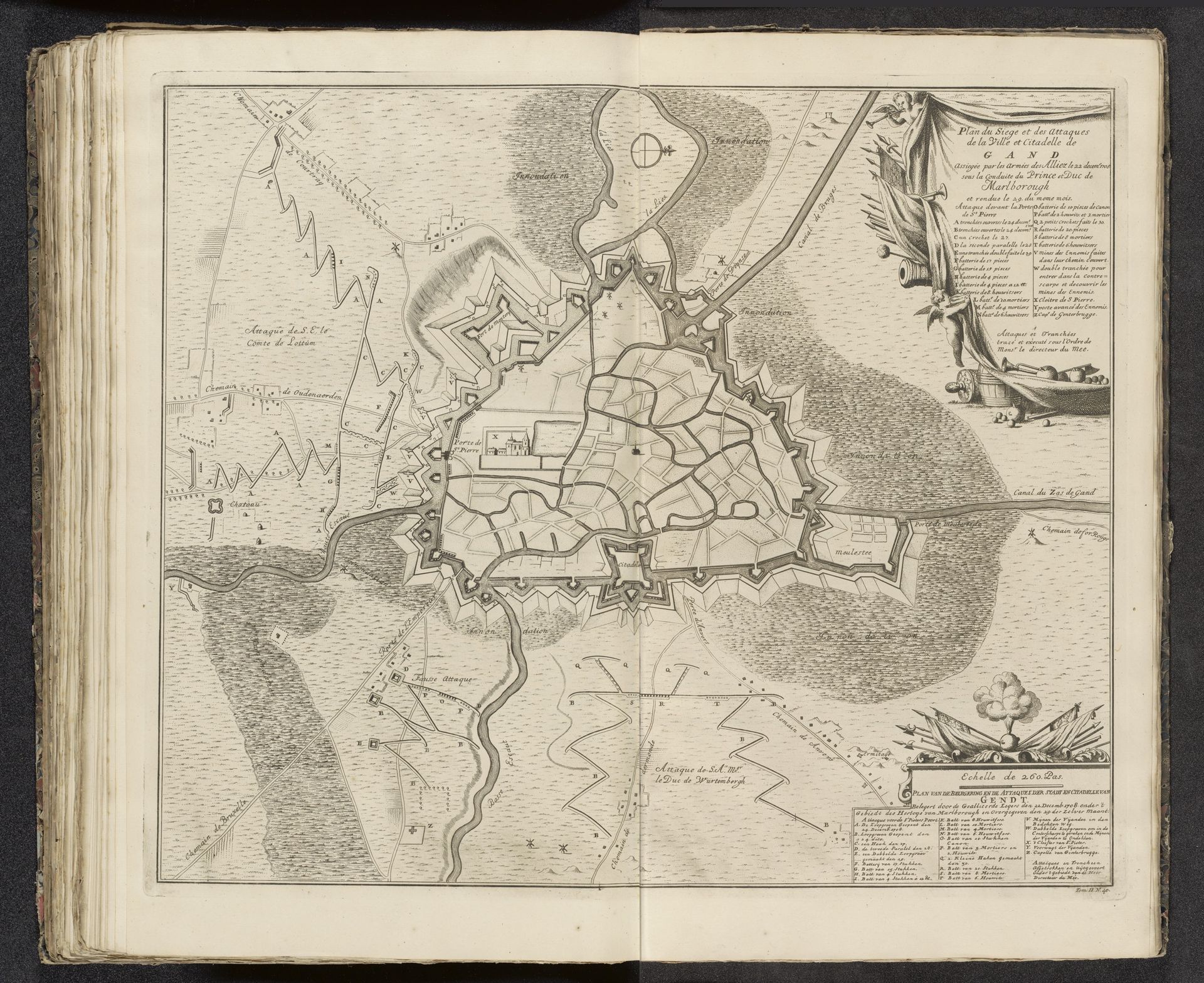
Pieter van Call the Younger created this map of the siege of Ghent in 1708. Note the strategic star-shaped fortifications encircling the city, symbols of military prowess, and the rigid geometry dictating the city's layout, reflecting an era of precise planning and control. Consider how similar star-shaped fortresses appear across Europe and the Americas during this time, each a testament to evolving military technology. This motif has distant echoes, dating back to ancient city walls and Roman castra, each adaptation marking a shift in societal needs and fears. Such a visual representation triggers a deep-seated psychological response—a fascination with power, security, and the eternal human drive to dominate and protect. It speaks to our collective memory of sieges, battles, and the ever-present threat of conflict. The image is not just a map but a reflection of the enduring human drama played out on the stage of history. It reminds us of how symbols of power and defense continually resurface, adapting to new contexts yet rooted in the ancient soil of human experience.
Plan van het beleg van Gent, 1708
1708 - 1729
Pieter van (II) Call
1688 - 1737Location
RijksmuseumArtwork details
- Medium
- print, engraving
- Dimensions
- height 505 mm, width 600 mm
- Location
- Rijksmuseum
- Copyright
- Rijks Museum: Open Domain
Tags
Comments
Share your thoughts
About this artwork
Pieter van Call the Younger created this map of the siege of Ghent in 1708. Note the strategic star-shaped fortifications encircling the city, symbols of military prowess, and the rigid geometry dictating the city's layout, reflecting an era of precise planning and control. Consider how similar star-shaped fortresses appear across Europe and the Americas during this time, each a testament to evolving military technology. This motif has distant echoes, dating back to ancient city walls and Roman castra, each adaptation marking a shift in societal needs and fears. Such a visual representation triggers a deep-seated psychological response—a fascination with power, security, and the eternal human drive to dominate and protect. It speaks to our collective memory of sieges, battles, and the ever-present threat of conflict. The image is not just a map but a reflection of the enduring human drama played out on the stage of history. It reminds us of how symbols of power and defense continually resurface, adapting to new contexts yet rooted in the ancient soil of human experience.
Comments
Share your thoughts