drawing, print, paper, ink, engraving
#
drawing
#
dutch-golden-age
# print
#
pen sketch
#
pencil sketch
#
landscape
#
paper
#
ink
#
geometric
#
pen work
#
engraving
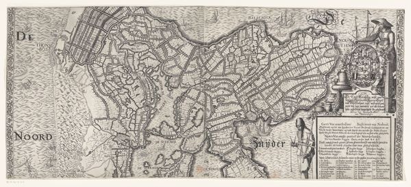
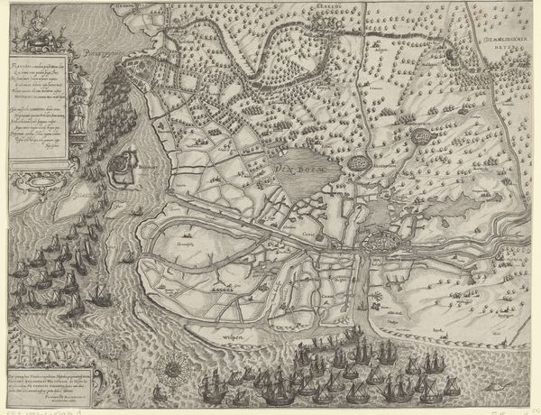
Dimensions: height 452 mm, width 556 mm
Copyright: Rijks Museum: Open Domain
Editor: This is a map called "Kaart van een deel van Zuid-Holland," dating from between 1629 and 1649. It's an anonymous work, a print with pen and ink on paper, currently held at the Rijksmuseum. It’s quite detailed! I find myself wondering how this map functioned within Dutch society at that time. What was its public role, do you think? Curator: That's an excellent question. Consider the Golden Age context: the Netherlands was a major maritime power. Maps weren't just geographical tools, they were instruments of power. Who commissioned it, and who had access to it, are important questions to consider. Editor: So, it's less about objective geography, and more about projecting power? Curator: Precisely! This map, even though it appears utilitarian, played a role in shaping perceptions of territory and control. It wasn’t just for navigation; it symbolized ownership and governance. The very act of mapping territory reinforces dominion, especially given the complex political landscape of the Dutch Republic then. Look at the precise rendering of the waterways – how might that have influenced trade and defense strategies? Editor: I didn't think about it that way! It seems so simple at first glance. Curator: Maps like this were also powerful tools of propaganda. By emphasizing certain features, they reinforced the idea of a prosperous and well-governed nation. Who do you imagine would be interested in displaying something like this? Editor: Perhaps wealthy merchants, or government officials? To show off their land holdings or demonstrate their awareness of trade routes? Curator: Exactly! This engraving allows us a glimpse into the ambitions and anxieties of the Dutch Republic at its peak. It prompts us to examine the power dynamics inherent in seemingly objective representations of the world. Editor: I've certainly learned a lot! Viewing art as historical artifacts opens a new perspective for me. Thanks for your help. Curator: The pleasure was mine. Remember, the public life of art is always intertwined with politics.
Comments
No comments
Be the first to comment and join the conversation on the ultimate creative platform.
More like this