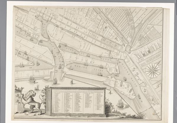
Kaart van de Omgestorte en onherstelbare Gebouwen te Leiden; Bij het springen van een met Buskruid geladen Schip, Op den 12 van Louwmaand 1807 1807
0:00
0:00
print, etching
#
neoclacissism
# print
#
etching
#
landscape
#
cityscape
#
realism
Dimensions: height 730 mm, width 430 mm
Copyright: Rijks Museum: Open Domain
Editor: Here we have a fascinating print, "Kaart van de Omgestorte en onherstelbare Gebouwen te Leiden; Bij het springen van een met Buskruid geladen Schip, Op den 12 van Louwmaand 1807," made by P. van Campen in 1807, utilizing etching techniques. The detail is striking, but there’s a real sense of devastation depicted. How does the socio-political climate of the time influence your interpretation of this work? Curator: That's a crucial question. This print isn't simply a map; it’s a carefully constructed piece of public memory. The disaster you mentioned, the explosion of a gunpowder ship, was a massive trauma for Leiden. This image becomes part of the narrative around the disaster and its impact. What message do you think the artist is trying to convey, especially considering the figures at the top of the map? Editor: I see a figure mourning on the left and one drawing or documenting on the right, creating a framed sense of both grief and an attempt to capture what remains after disaster. What role do you believe museums and institutions played, or were intended to play, in shaping public opinion in its aftermath? Curator: Precisely. And museums were beginning to find their footing in society as arbiters of taste and even more importantly as locations for documenting social events. This print, sold and distributed, helps shape the perception of that tragedy. It subtly reinforces narratives of resilience, of Leiden's capacity to rebuild itself, of offering assistance. What do you think of the neo-classical elements here in terms of historical record-keeping? Editor: The choice of Neoclassicism feels significant—a conscious nod towards order and rationality in a moment of utter chaos, and an interesting link back to similar classical ruin paintings or prints which remind audiences that even the greatest achievements can fall. Curator: Exactly. This work showcases that visual communication goes far beyond objective reporting; it constructs a shared understanding and experience. This brings up broader questions around any artwork’s social purpose and impact. Editor: This conversation has broadened my perspective. It’s more than just a historical document; it’s a political and social statement, shaped by the artist's choices and the context it was created within. Thank you! Curator: And I agree. By understanding its various layers, we are closer to recognizing how it impacted social thought.
Comments
No comments
Be the first to comment and join the conversation on the ultimate creative platform.
