print, engraving
baroque
history-painting
engraving
Dimensions: height 510 mm, width 596 mm
Copyright: Rijks Museum: Open Domain
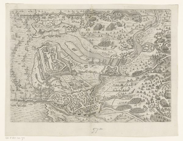
This is an anonymous map of the surroundings of Cartagena, depicting the battle of 1741. It offers a chilling look at the intersection of cartography, conflict, and colonialism in the Americas. Maps like this one weren't just about geography; they were tools of power. Consider the act of mapping itself. Who gets to define the boundaries, claim the territory, and name the places? The map reflects the worldview of the colonizer, turning a complex human landscape into a space of strategic advantage. The ships positioned, ready for battle, underscore the violence inherent in this act of claiming. The visual precision used in the map flattens a narrative which involved power, identity, and historical context. Notice too the absence of indigenous perspectives. Where are the voices and experiences of the people who lived on this land long before the arrival of the Europeans? This map isn't just a representation of space; it's a representation of a particular kind of history, one that silences and erases other stories. It serves as a potent reminder of the power of perspective and the importance of seeking out multiple narratives when we look at the past.
Comments
No comments
Be the first to comment and join the conversation on the ultimate creative platform.