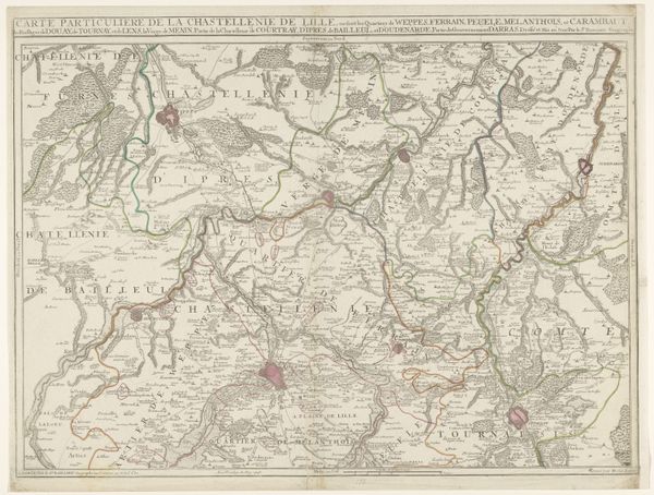
Kaart van het graafschap Namen met de posities van de Geallieerde en Franse legers, 1692 1692 - 1720
anonymous
Rijksmuseum
print, etching
etching
landscape
geometric
history-painting
academic-art
Dimensions: height 488 mm, width 615 mm
Copyright: Rijks Museum: Open Domain
Curator: Welcome. Today we are looking at "Kaart van het graafschap Namen met de posities van de Geallieerde en Franse legers, 1692," which translates to "Map of the County of Namur with the positions of the Allied and French Armies, 1692." This print, crafted through etching, offers a snapshot of a critical moment in military history. Editor: It’s amazing how much information is packed into this image. The lines denoting troop movements really capture your attention and gives me a sense of constant war being waged, yet balanced with a surprisingly delicate depiction of the landscape. Curator: The map gives a birds eye perspective on how materials would have been deployed across the landscape. In studying the printmaking process itself, one has to marvel at the skill required to transfer such a detailed cartographic image onto the plate with all the place markers being etched to then allow mass reproduction. The standardization of borders also speaks volumes about resource control. Editor: Indeed. What is equally intriguing is that it provides visual context to war. Thinking about identity, nationalism, the ruling and the subjugated–what does the militarization of civilian space tell us about social order and access to geographical movement? Curator: Absolutely. It serves as a reminder of how maps have historically been tools of power and governance. Who makes them? For what purpose? What's included and what's excluded from this representation? Are there trade routes indicated for civilian consumption? Where does food and weaponry get deployed? These aspects also underline its significance beyond a mere historical artifact; these tools impact the labor behind resource procurement and allocation in times of war. Editor: And who has access to the information it provides. It’s about land and how this control impacts lives, power dynamics, the very fabric of societies shaped by such events. What was the colonial relationship? The question for us is whose names get to appear on the map versus those who remained unnamed? Curator: True. Thinking through the technical means for knowledge dissemination while questioning its selective scope opens paths to question its lasting legacies on those impacted, generation after generation. Editor: Maps like this one hold multiple layers, revealing the human element through socio-political dimensions that encourage discussion even today. Curator: Precisely. Looking closely at this, we come to understand how meticulous execution when harnessed through historical record is key to interpret how it represents and distributes global impact of a place through the course of its making.
Comments
No comments
Be the first to comment and join the conversation on the ultimate creative platform.