drawing, print, ink, pen
#
drawing
#
baroque
# print
#
pen sketch
#
ink
#
geometric
#
pen-ink sketch
#
pen
#
cityscape
Dimensions: height 222 mm, width 295 mm
Copyright: Rijks Museum: Open Domain
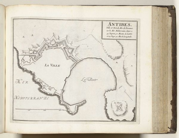
Curator: We're looking at an ink drawing from around 1702, titled "Plattegrond van Antibes," now held at the Rijksmuseum. It presents a detailed map of Antibes, France, at the turn of the 18th century. Editor: The crisp lines and careful details immediately suggest order and control. It feels very deliberate, a sort of architectural snapshot. What stands out to you most? Curator: Well, for me, it’s fascinating to consider the production of such a piece. Someone, likely employed by the military or a wealthy patron, carefully surveyed the landscape to produce this visual representation. The labor and specific context really shape how we see this, don't you think? Editor: Absolutely, but it’s equally fascinating how the formal arrangement enhances that sense of power. The strong geometric forms, the calculated angles of the fortifications, these all speak to a visual language of dominance. It’s not just about the “how,” but about the visual encoding of power dynamics within the image. Curator: True. Think about who had access to such visual documentation. Mapping was power, strategic knowledge distributed selectively to serve particular interests, especially given the geopolitical climate of Europe at that time. Editor: And what about the bare materiality of ink on paper? It underscores the way that something as grand as city planning is distilled to elemental visual components, revealing the underlying structure and form, not only of the town itself but the conceptual architecture of its governing structures. Curator: And consider the sheer investment of time in creating this meticulous portrayal; it reflects the growing mercantile and military interest that states were beginning to take in mapping. It moves us beyond a mere visual experience of a city to its social and material realities. Editor: Seeing these geometric articulations really allows us to unpack the syntax of early modern urban planning and to investigate its effect on the overall formal composition. We start to see cities not just as collections of people and buildings, but as designed constructs and coded spaces. Curator: This piece exemplifies how studying art requires an acknowledgment of both material circumstances and ideological agendas. Looking at the human impact—the who, how, and why this came into being, and who it ultimately served to benefit. Editor: Seeing beyond the labor, beyond the physical and historical factors, to understanding that these were structures being visualized—structures dictating daily lives, both then and today. Curator: Indeed, this offers a deeper understanding not only of this specific map, but also of art’s social and historical positioning. Editor: Leaving me with an awareness of form and making visible, tangible connections of city plans, people, and life that exists, thanks to this artwork's historical survival.
Comments
No comments
Be the first to comment and join the conversation on the ultimate creative platform.
More like this