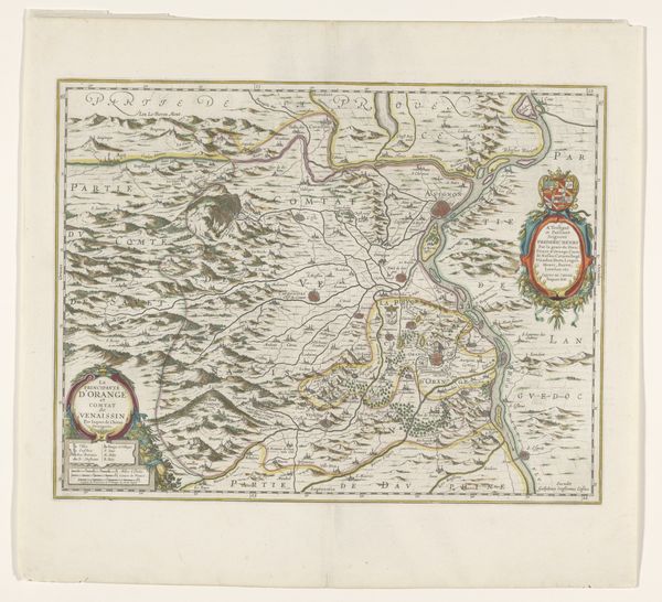
Kaart van de Baronie van Breda en het Markgraafschap van Bergen op Zoom 1739
0:00
0:00
jacobkeyser
Rijksmuseum
print, engraving
#
baroque
# print
#
old engraving style
#
landscape
#
engraving
Dimensions: height 286 mm, width 330 mm
Copyright: Rijks Museum: Open Domain
Curator: Here we have a detailed 1739 map, an engraving by Jacob Keyser. It depicts the Barony of Breda and the Margraviate of Bergen op Zoom, presently on view here at the Rijksmuseum. Editor: It strikes me as surprisingly delicate. Look at the incredibly fine lines, and the almost pastel-like wash of colours used to demarcate the territories. The precision seems remarkable for the period. Curator: Precisely. The aesthetic value resides significantly in the fineness of the lines and the compositional balance achieved through careful arrangement of text and geographic details. Notice how the topography itself becomes a visual pattern, a complex weave of textures. Editor: It is more than just aesthetic; consider the socio-political importance of this visual representation at the time. Land was power. Mapping defined territories, declared ownership, and laid claim to resources. These weren’t just beautiful objects; they were strategic assets. Who was this Keyser? What was his role in documenting this geographical and political landscape? Curator: We know very little of the artist. However, let’s return to the object itself: the use of cartouches to frame the title. Note the almost decorative quality given to the map's legend, acting not simply as informational keys, but adding a symbolic weight. They provide structure as both image and text. Editor: Right. And I read those markers of power—those delineations between one territory and another—as narratives of conflict. Look at how close Breda and Bergen op Zoom are; there is also a suggestion of expansion or defence in these border areas. Was it originally produced for public dissemination or limited governmental distribution? What did "ownership" of such a visual object confer at this moment in time? Curator: Irrespective of these contextual questions, a map’s beauty lies in this graphic reduction and reorganization of something much larger. I find immense satisfaction in considering such refined construction. Editor: It is compelling as both a visual artifact and as an important source that reflects cultural and geopolitical imperatives in 18th century Europe. Thanks to artifacts like these, we see the physical and symbolic shaping of a world.
Comments
No comments
Be the first to comment and join the conversation on the ultimate creative platform.
More like this