drawing, print, paper, engraving
#
drawing
# print
#
landscape
#
paper
#
cityscape
#
engraving
Dimensions: height 239 mm, width 277 mm
Copyright: Rijks Museum: Open Domain
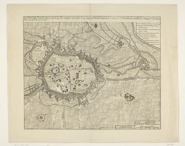
Curator: Here we have Abraham Allard’s "Plattegrond van Mainz," a city map dating from the period of 1702 to 1733, currently residing at the Rijksmuseum. The artwork combines drawing and print techniques on paper. Editor: It’s so interesting! My first thought is how incredibly detailed it is for a relatively small format. You can almost trace the layout with your finger, sensing the textures of paper, ink, and engraving, thinking about the meticulous labor. Curator: Indeed! What draws my eye are the almost star-like geometric figures layered into the lower portion, and I notice "Goffesrvesburg" near one of them, suggesting military fortifications are charged with sacred symbolism, perhaps protecting the sacred city. Editor: Absolutely. Look at how those elaborate fortifications integrate directly into the city plan. It emphasizes Mainz’s strategic importance, no doubt related to military and trade logistics dependent on its geographic positioning between rivers. Think of the planning, the sheer manpower involved! Curator: Note too how the rivers – the "Rhenus," the Rhine, and the Main – dominate the visual space. Water as both life source and dividing force is key to understanding the psychological experience of those living here. This landscape *is* their experience, encoded for us in ink. Editor: That river dominance shapes material reality, both then and now. Consider the resources derived from it: the fish, the trade routes, and the potential for defense. Engraving was used for printing since it allowed for longer printing, thus this was a good medium of disseminating important geopolitical information to decision-makers. Curator: Do you see how Mainz rises like an island, set apart both literally and symbolically by those waterways? Allard doesn’s simply present a plan, but suggests something deeper, a collective imagining. Editor: I do now. Thank you! I now see it is both an artistic rendition, a technical drawing, and, fundamentally, about the materials that constituted life for the early modern inhabitants, shaped by conflict and commerce.
Comments
No comments
Be the first to comment and join the conversation on the ultimate creative platform.
More like this