drawing, print, paper, ink, engraving
drawing
toned paper
baroque
pen drawing
pen sketch
old engraving style
paper
personal sketchbook
ink
ink drawing experimentation
pen-ink sketch
pen work
sketchbook drawing
cityscape
sketchbook art
engraving
Dimensions: height 382 mm, width 478 mm
Copyright: Rijks Museum: Open Domain
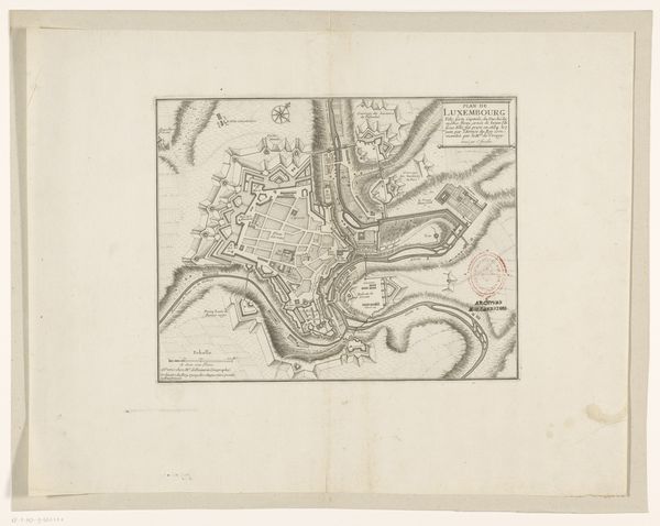
Curator: Here we have an engraving from 1657 entitled "Plattegrond van Salzburg," attributed to an anonymous artist. It's quite detailed, isn’t it? Editor: It is. The density of detail gives me an immediate impression of order and control, yet also a certain anxiety, perhaps reflective of a society concerned with borders and defence. Curator: Yes, look at the prominent fortifications, particularly that star-shaped citadel dominating the lower part of the map. The clean lines and precise angles speak to a very particular understanding of space. Do you notice how the river Salzach bisects the city, creating a natural division reflected in the composition? Editor: I do. Rivers have long played an interesting role dividing populations, in this instance literally carving Salzburg into sections and delineating communities with different socio-political agendas, doesn't it strike you so? Curator: Structurally, absolutely. The sharp delineation is very effective at separating and defining these elements. Note also the use of varying line weights and shading to suggest depth. The cityscape almost rises from the page. The lines almost feel alive. Editor: It's fascinating to think about what this map leaves out, too. Beyond the imposing structures representing power, I can imagine lives of labor, the unsanctioned aspects of this city, particularly the communities disenfranchised and living along the margins who inevitably faced limited access and resources. What might their version of Salzburg look like, had they the opportunity to document it? Curator: An intriguing question. It makes you realize how subjective cartography could be, even then. But considered on its own terms, as a statement about order and proportion, the artist really achieves something extraordinary. Editor: I agree. This map, whether intended or not, functions not just as a spatial representation but also a powerful symbol of authority and the socio-economic hierarchies it maintained during that time. The meticulous precision stands in contrast to the imprecision in our human accounts, I think. Curator: Well put. A convergence of structure and cultural implication, then. Editor: Precisely.
Comments
No comments
Be the first to comment and join the conversation on the ultimate creative platform.