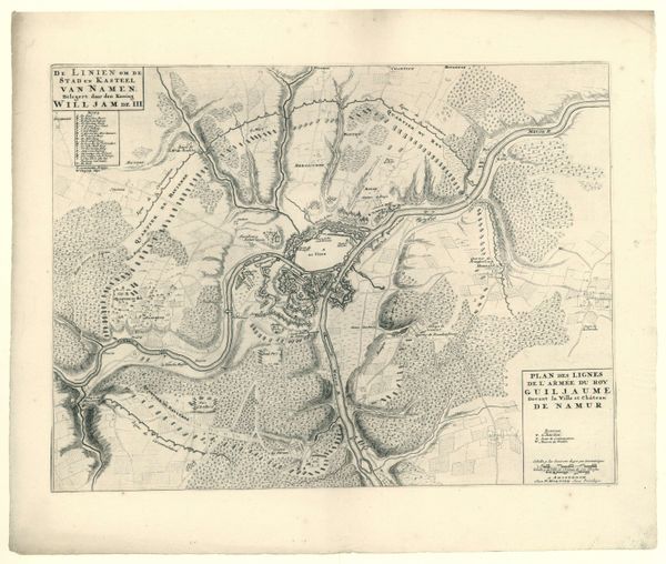
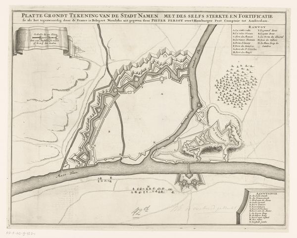
Plattegrond van de stad Namen met het kasteel, belegerd door het Franse leger, 1692 1692 - 1720
0:00
0:00
anonymous
Rijksmuseum
print, engraving
#
baroque
# print
#
old engraving style
#
geometric
#
cityscape
#
history-painting
#
engraving
Dimensions: height 432 mm, width 578 mm
Copyright: Rijks Museum: Open Domain
Curator: Here we have an anonymous print from between 1692 and 1720, titled “Plattegrond van de stad Namen met het kasteel, belegerd door het Franse leger, 1692.” It depicts a map of the city of Namur and its castle during its siege by the French army. It’s currently held in the Rijksmuseum. Editor: My first impression is one of overwhelming detail. It feels almost sterile, despite the subject matter, because of the precise, almost clinical rendering of the city. You can almost smell the gunpowder but there is no human chaos rendered in the engraving. Curator: Right. What’s fascinating is the use of the bird's-eye view, offering a strategic overview. It highlights how these cityscapes weren't just aesthetic objects, they functioned as military intelligence, circulated among powerful rulers, shaping decisions of war. You see that even in the elaborate legend describing the fortifications and attacks. Editor: Precisely! It’s crucial to remember the role this played within the context of almost constant European warfare. Maps weren't neutral documents; they were political tools projecting power and strategic advantage. Who controlled the map controlled the narrative, not just the land. Also I note the cherubic figures decorating the print on the upper and lower right - an incongruous feature. Curator: The cherubs and baroque flourishes are a perfect example of how even technical documents like these got caught up in the aesthetics of power at the time, fitting nicely into baroque sensibilities. The city, reduced to line and form, almost becomes an abstraction, a prize to be won. I'm sure those living in Namur at the time would not appreciate it being treated as just an abstract form! Editor: And who got to tell that story? That absence of lived experience, the simplification of human impact to mere geometry is what sits uneasily with me. It reminds us of the narratives that dominate and whose voices remain silent. Curator: Well, considering it was a military operation, I suppose that lived experiences of the local inhabitants are an unintended omission rather than an intended erasure. Regardless, I concur with you that, when seen with today’s sensitivity to inclusivity, the view rendered in this artwork is sadly lacking. Editor: I think examining this anonymous print challenges us to be critical of supposedly objective viewpoints, because even a map serves an agenda and embeds the biases of its creators and sponsors. I think I see history with fresh eyes after this brief discourse.
Comments
No comments
Be the first to comment and join the conversation on the ultimate creative platform.
More like this