print, engraving
#
dutch-golden-age
# print
#
pen illustration
#
old engraving style
#
landscape
#
geometric
#
cityscape
#
history-painting
#
engraving
Dimensions: height 308 mm, width 390 mm
Copyright: Rijks Museum: Open Domain
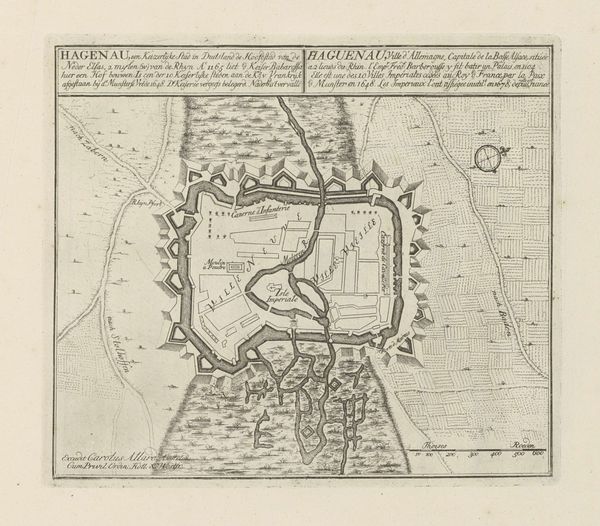
Curator: This finely detailed engraving from 1743, titled "Versterkingen rond Breda in 1622 door Maurits aangelegd," depicts the fortifications around Breda as established by Maurits. The piece is attributed to B.F. Immink. Editor: Immediately, what strikes me is this network of geometric shapes that radiate outward. It projects such a powerful visual metaphor for control, doesn’t it? Like a web spun to ensnare. Curator: Precisely. Note how the artist has used line and form to create a powerful sense of spatial organization. The geometric forms of the fortifications, layered and meticulously rendered, speak to a very specific aesthetic sensibility, the logic of the grid imposed upon the natural landscape. Editor: And the historical context is vital here. Breda, strategically important, was central in the Eighty Years' War. This isn't just a visually interesting map; it's a representation of power, territoriality, and the struggle for independence, memorializing Prince Maurits's strategic ingenuity, and perhaps romanticizing it somewhat. Curator: I would suggest, however, that while socio-political readings are indeed relevant, the work's intrinsic artistic merits also demand attention. The rendering of depth, the use of hatching to model the land— Editor: But the very act of representing fortifications serves a specific ideological purpose. This map does not exist in a vacuum. Its visual order normalizes power structures, influencing how the public perceives military endeavors and leadership during times of war and thereafter. The very clarity it projects conceals the inherent violence it represents. Curator: Nonetheless, appreciate the elegance of the engraving. Look at the precision. One cannot deny the technical skill on display and its own form of symbolic language that elevates functionality to art. Editor: I concede the artist’s skillful handling of technique, certainly, but through my perspective, the work evokes something far more unsettling—a clear reminder of how art can be complicit in shaping narratives of dominance and control through idealized visualizations of martial strategies and their justifications in historical chronicles. Curator: Well, I find that exploring the intricate details of this print and contemplating its balance between form and function offers insights into a period when art, science, and warfare were inextricably linked. Editor: For me, considering the historical conditions in which art is created allows a much richer interpretation that acknowledges art's potential to both reflect and reinforce power dynamics in any given moment, a perspective that ultimately leads to an awareness about contemporary conditions, too.
Comments
No comments
Be the first to comment and join the conversation on the ultimate creative platform.
More like this