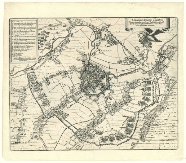
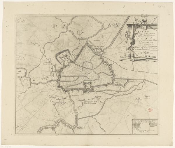
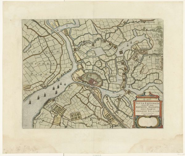
painting, watercolor
baroque
painting
watercolor
cityscape
history-painting
watercolor
Dimensions: height 464 mm, width 555 mm
Copyright: Rijks Museum: Open Domain
Curator: What strikes me immediately is the delicacy of line, particularly for a document relating to siege warfare. It’s almost precious, this “Plan van het beleg van Gent, 1708,” dating from around 1709-1732, crafted with watercolor by Pieter van (II) Call and held in the Rijksmuseum collection. Editor: Precious is a perfect word! And somewhat dissonant, isn't it? One doesn't necessarily associate watercolour washes with the violence inherent in a siege. There’s something almost diagrammatic in the layout – look at how the city is segmented, categorized through color. The muted palette lends an air of antiquity, an aesthetic distance from the brutal realities depicted. Curator: Indeed. Maps have always served ideological purposes. Note how the orderly city within its fortifications contrasts so starkly with the unruly, vaguely-defined terrain outside. This is no objective record; this is a carefully constructed representation of power and control, emphasizing the strategic, even intellectual, aspects of war. The surrounding fortifications aren’t just physical defenses; they become visual metaphors for stability, European civilization holding strong in conflict. Editor: It's tempting to see the Baroque sensibility reflected in this plan as well. The cartouches, flags, cannon... all positioned so proudly at the upper-right of the frame, the symbolic apparatus is rather ornamental in its precision. The almost topographic concern extends to even the surrounding fields, notating the sinuous rivulets. Each element contributes to the reading, in totality. Do you read this preoccupation with detailed depiction to also emphasize, for instance, a specific lineage of military leadership? Curator: I do. The inclusion of celebratory details --the flags, coats of arms—speak directly to lineage, conquest, and the heroic narrative, a potent statement of Dutch identity. Think about how such images functioned: displayed in homes or public buildings, these maps didn't just inform—they solidified cultural memory and affirmed existing hierarchies. It all boils down to legacy and legitimacy. Editor: So much embedded ideology. It invites closer looking… I think what once appeared ‘precious’ reveals itself instead as precisely calibrated, its formality a mask obscuring both ambition, loss, and conquest. Curator: A precise understanding, I believe. These artifacts were tools—powerful statements—of a complex worldview.
Comments
No comments
Be the first to comment and join the conversation on the ultimate creative platform.