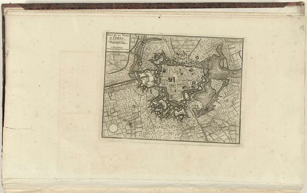
print, engraving
# print
#
cityscape
#
engraving
Dimensions: height 83 mm, width 109 mm
Copyright: Rijks Museum: Open Domain
This is Philippe Vandermaelen's "Plattegrond van Antwerpen," a map of Antwerp, though the exact date of its making isn't known. It’s printed on paper, likely using an etching or engraving technique. Notice how the precision of the lines and the intricate details give the map its form. Cartography like this was a highly skilled occupation, demanding expertise in draftsmanship and printing processes. The physical act of creating such a map involved meticulous labor: drawing, etching, and inking. It was then printed, possibly in multiples for distribution, each stage requiring careful attention and skilled hands. This wasn't just a functional object; it also reflected the ambition of 19th-century commercial culture, where accurate representation and dissemination of information became increasingly important. It highlights the interplay between artistic skill, industrial production, and the wider context of societal development. This challenges traditional art history's divide between fine art and practical craft, showing how deeply intertwined these categories were.
Comments
No comments
Be the first to comment and join the conversation on the ultimate creative platform.
More like this