drawing, print, engraving
#
drawing
#
baroque
# print
#
landscape
#
geometric
#
line
#
cityscape
#
engraving
Dimensions: height 243 mm, width 415 mm
Copyright: Rijks Museum: Open Domain
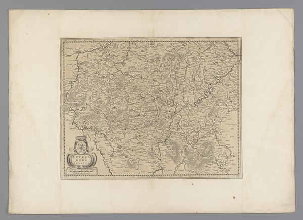
Curator: Well, isn't this fascinating! What you're looking at is a detailed print from 1735, titled "Kaart van de kasselrij Veurne," or "Map of the Castellany of Veurne," a drawing made using engraving. The cityscape and landscape are wonderfully depicted with this line style. Editor: My first thought is how intricate and ordered it appears. There is something about the almost rigid network of lines that feels very deliberate and controlled, despite depicting a landscape. I wonder about the social implications of such a highly structured representation of space. Curator: Indeed! It’s essential to understand maps like this one not just as representations of geography, but as objects with political weight. Mapping was a key tool for states and other authorities. This was more than mere recording; it was a way of asserting ownership and control over territory. Editor: Exactly! We have to consider who commissioned it, who produced it, and who it was intended to serve. Maps like this were often tools of governance, visualizing and reinforcing existing power structures. Who had the skill and the economic means to produce something so precise and, frankly, beautiful? Curator: We also see that this involved highly skilled labor. Engraving requires incredible precision. Look at the subtle variations in line thickness used to denote different features. Think of the engravers' workshops, the cost of materials like copper plates and paper, and the distribution networks required to disseminate the final prints. Editor: And how did this kind of mapmaking influence other visual culture? Did its style filter into other forms of craftsmanship or artistic expression within the communities represented? Was this precision aesthetic tied to a particular vision of civic order or mercantile activity? Curator: It undoubtedly fed into other artistic practices and shaped how people perceived and interacted with their surroundings. This level of detail encouraged a certain way of seeing and knowing the land, potentially impacting agriculture, trade, even social mobility. Editor: Absolutely. It invites us to consider not just the geographical representation, but the socio-economic context surrounding its creation and dissemination. Who benefits from this type of detailed control, and how does this control translate to art in practice? Curator: It’s been helpful examining this from these two different perspectives. I have a newfound appreciation for the hands involved in production. Editor: I agree. This conversation truly highlighted how social and political power is displayed with this city and landscape scene and print.
Comments
No comments
Be the first to comment and join the conversation on the ultimate creative platform.
More like this