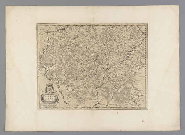
print, etching, paper, engraving
#
baroque
# print
#
etching
#
landscape
#
paper
#
engraving
Dimensions: height 525 mm, width 732 mm
Copyright: Rijks Museum: Open Domain
Curator: Here we have “Kaart van een deel van Vlaanderen,” or “Map of a Part of Flanders,” an etching and engraving on paper made in 1638. Editor: It’s incredibly detailed. Almost feels… cool, in tone. The precise lines create a sense of detached observation. Curator: Indeed. As a printed map, it embodies the material means by which geographical knowledge was disseminated. The engraving technique itself—the labor involved in carving those lines into the plate—speaks to a growing market for accessible information and an increasingly literate populace in the Baroque era. Editor: Right, the socio-political context. Maps were definitely power, weren’t they? This wasn’t just about knowing where you were; it was about ownership, control. Looking at the heraldic imagery, the dedication cartouche…this print probably served a very specific political function, defining territories and solidifying claims of ownership for the Duchy of Aarschot? Curator: Precisely. And consider the paper it’s printed on: handmade, surely. Where was the paper sourced? What was the water quality like that affected its colour and life? These factors point to specific economic conditions within the Flemish region at that time, conditions that would then influence the ability to distribute such items of 'soft power'. Editor: And those decorative elements—the flourishes and putti adorning the map’s cartouches—they transform this document from pure utility into a statement piece, elevating the map from a navigational tool to a political representation of power and taste. It's propaganda of sorts! Curator: But beautiful propaganda, rendered possible through specific craft techniques, distributed amongst a growing public of potential patrons, politicians and educated classes that sustained the mapmakers, engravers, distributors and purchasers within the Netherlands in 1638. Editor: Looking at it now, I appreciate that the Baroque style, with its characteristic flamboyance, isn’t just superficial ornamentation here. It's integral to how this map performs its function, legitimizing the Duchy’s claim over this specific piece of Flanders. Curator: Precisely. Looking at it through the lenses of process and historical positioning helps highlight this material and political complexity. Editor: It definitely adds another layer to how we can think about historical imagery, moving beyond mere decoration to really interrogate the context.
Comments
No comments
Be the first to comment and join the conversation on the ultimate creative platform.
More like this