drawing, print, engraving
#
drawing
#
baroque
# print
#
geometric
#
line
#
cityscape
#
engraving
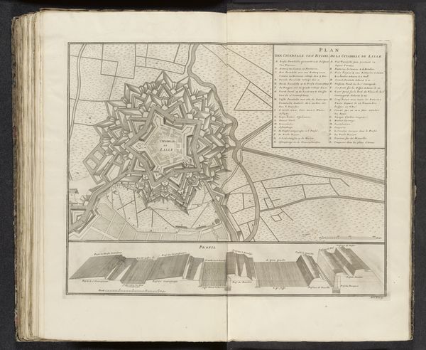
Dimensions: height 505 mm, width 595 mm
Copyright: Rijks Museum: Open Domain
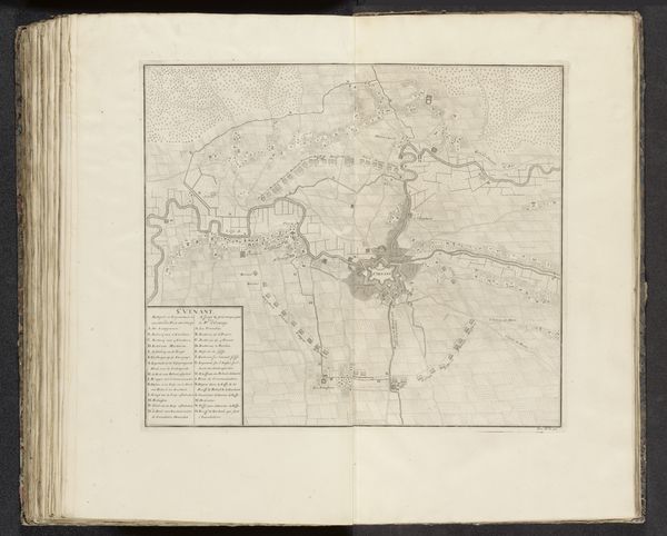
Curator: What strikes me immediately about this rendering of Lille, dating from the early 18th century and attributed to Pieter van Call, is its intricate geometrical perfection. The precision of the lines almost belies its practical purpose as a city plan. Editor: I see that geometric precision, yes, but my immediate reaction is to its function as an assertion of power and control. Think about who commissions such maps – usually states, militaries, or colonizers seeking to organize and ultimately dominate space. Curator: That's a compelling perspective. The sharp lines and rigid structure speak to the broader impulse for the ordering of knowledge, for the Enlightenment’s project of categorization that facilitated empire building and capitalist expansion through visual representation. But looking at this print, especially at the walled city centers surrounded by those star-shaped fortifications, it's hard not to see the influence of Baroque aesthetics, and especially how perspective shapes our understanding. Editor: I agree about perspective; that’s key here. Maps aren’t neutral records, are they? They actively construct particular realities by emphasizing specific information, concealing others. I am also struck by the contrast between the regimented space within the city walls and the wilder, less defined spaces outside, raising questions about center and periphery. Who belongs, who is excluded? Where is social inequality visible in its very design? Curator: The level of detail is mesmerizing. If we consider, for instance, that each building represents a dwelling, a workshop, a life lived, we begin to imagine the multitude of experiences contained within those walls. The map almost performs a kind of social archaeology. Also, thinking of van Call himself as a cartographer creating such an image and engraving these lines with astonishing care—this speaks to craft and artistic practice far more broadly. Editor: Absolutely. It is an important example of urban planning but also colonial ambition rendered in fine lines. Reflecting on its construction invites us to question the very systems it supported. Curator: Agreed. Close observation reveals as much about artistic skill as it does about political ideologies of its moment. Editor: Yes, a potent intersection of form and function—challenging us to see beyond surface appearances.
Comments
No comments
Be the first to comment and join the conversation on the ultimate creative platform.
More like this