drawing, print, paper, ink
#
drawing
# print
#
paper
#
ink
#
geometric
#
cityscape
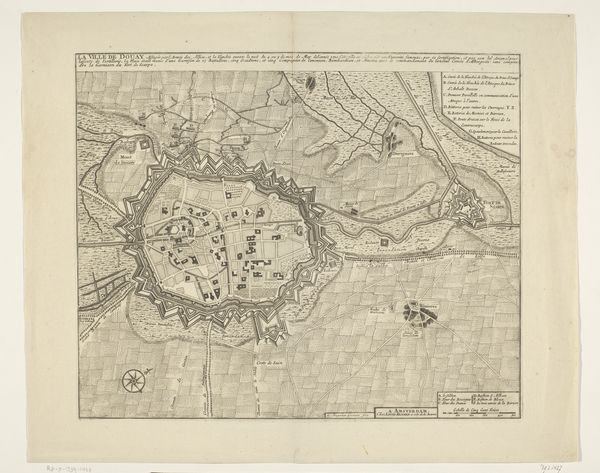
Dimensions: height 505 mm, width 580 mm
Copyright: Rijks Museum: Open Domain
Editor: This is a printed map of Brussels, created sometime between 1727 and 1729. It's incredibly detailed! I'm struck by the city walls, these imposing fortifications surrounding the entire city center. What does the map communicate to you? Curator: I'm immediately drawn to those very fortifications, as well. They are not just practical barriers; they are profound symbols of identity, protection, and even fear. Notice the geometric precision, each angle a statement. How do you think this imagery impacted the psychological landscape of someone viewing this map in the 18th century? Editor: I imagine it offered a sense of security, knowing the city was well-defended. But it probably also reinforced a feeling of being contained. A kind of gilded cage maybe? Curator: Exactly! The visual language speaks volumes about power dynamics. Maps like these weren’t simply informational. They were instruments of power, used to define territory and control populations. Even the absence of something, like maybe certain landmarks downplayed or left out, tell us something of those holding the power to create it. What else stands out to you about how this city is represented? Editor: I notice the detailed key along the side, meticulously labeling various points of interest. This hints at the city's effort to showcase important religious and administrative spaces. Curator: Yes, and notice where those spaces are positioned relative to the walls, the placement within the "safety" and structure. This placement can suggest how Brussels defines and upholds societal values. Does this shift how you see the map's meaning, its visual language? Editor: Absolutely! It highlights the intentionality behind even seemingly objective representations. It shows me to not only examine *what* is shown, but what *isn't*, and *why*. Curator: Precisely. This isn't just a map; it's a cultural artifact, packed with stories and loaded with symbolism. These aren't simple lines and shapes; it's an image of who we were then and who we want to be.
Comments
No comments
Be the first to comment and join the conversation on the ultimate creative platform.
More like this