drawing, paper, ink, engraving
#
drawing
#
aged paper
#
toned paper
#
medieval
#
sketch book
#
paper
#
personal sketchbook
#
ink
#
geometric
#
pen-ink sketch
#
pen and pencil
#
pen work
#
sketchbook drawing
#
cityscape
#
history-painting
#
storyboard and sketchbook work
#
sketchbook art
#
engraving
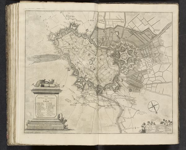
Dimensions: height 448 mm, width 555 mm
Copyright: Rijks Museum: Open Domain
This is an anonymous rendering from 1708, depicting a 'Plan of the Citadel of Lille'. Executed in ink, the work presents a rigorously structured layout, its geometric forms stark against the page. Notice how the citadel's star shape dominates, a series of angular protrusions designed for military defense. Lines delineate the complex network of fortifications, creating spatial depth. The map isn’t just a factual record; it’s a visual system. Each line, each shape functions as a signifier within a strategic semiotic framework. Roads and land plots are laid out systematically following a grid system, yet the outer perimeter of the citadel is more organic. Consider how this map reflects a desire to impose order on space, turning landscape into a set of coded symbols. It's a Cartesian vision, translating the messiness of the world into rational, manageable forms. This plan embodies the Enlightenment’s faith in reason and its ambition to control the environment through knowledge. The emphasis on geometric precision reveals an underlying belief in the power of structure.
Comments
No comments
Be the first to comment and join the conversation on the ultimate creative platform.
More like this