About this artwork
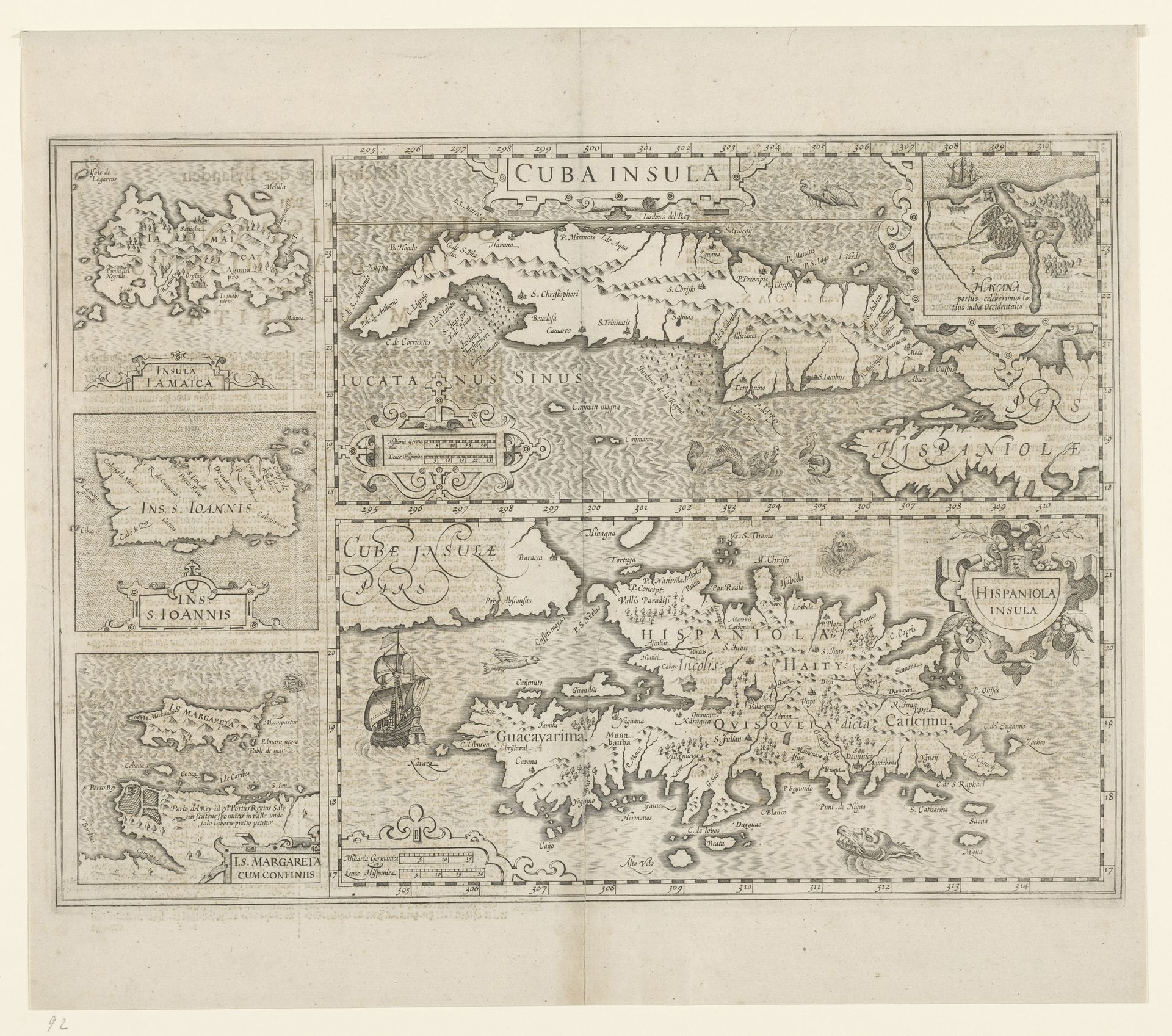
Editor: We're looking at a 17th-century engraving, "Kaart van vijf Caraibische eilanden" – a map of five Caribbean islands: Cuba, Haiti, Jamaica, Puerto Rico, and St. Margareta, by an anonymous artist. It's quite detailed for its time, but I find myself mostly drawn to the varying textures used to represent land and water. What compositional elements stand out to you? Curator: Immediately apparent is the division of the pictorial space into discrete, framed units. The artist employed a strategy of compartmentalization. Observe how each island is presented not in relation to a unified, comprehensive field, but as an isolated, self-contained entity. Editor: So, each island is almost its own little world, separated from the others despite their geographical proximity. Curator: Precisely. And note the interplay between the cartographic and the decorative. The meticulous rendering of coastlines and settlements coexists with ornate flourishes, such as the calligraphic inscriptions and the depiction of sea monsters. How do these stylistic juxtapositions affect your perception of the map's purpose? Editor: Well, the decorations almost undermine its credibility as a purely scientific document. It feels more like an artistic interpretation. But, is the emphasis of aesthetic the focus of the artwork, and what does that artistic decision make one think of the culture producing this object? Curator: Consider how this map embodies a negotiation between objective representation and subjective expression. The very act of selection – which islands to include, how to orient them, what details to emphasize – constitutes an interpretation. The question then becomes: through what formal means does the artist convey his particular understanding of these spaces? Editor: It's like they're presenting a collection of curated ideas, as much as a geographical reference! I hadn’t thought about it that way before. Curator: Indeed. The framing invites us to analyze the work as an object with complex, rather than obvious and unified meanings.
Kaart van vijf Caraibïsche eilanden: Cuba, Haïti, Jamaica, Puerto Rico en St. Margareta
1606 - 1634
Anonymous
@anonymousLocation
RijksmuseumArtwork details
- Medium
- graphic-art, print, engraving
- Dimensions
- height 362 mm, width 498 mm
- Location
- Rijksmuseum
- Copyright
- Rijks Museum: Open Domain
Tags
Comments
Share your thoughts
About this artwork
Editor: We're looking at a 17th-century engraving, "Kaart van vijf Caraibische eilanden" – a map of five Caribbean islands: Cuba, Haiti, Jamaica, Puerto Rico, and St. Margareta, by an anonymous artist. It's quite detailed for its time, but I find myself mostly drawn to the varying textures used to represent land and water. What compositional elements stand out to you? Curator: Immediately apparent is the division of the pictorial space into discrete, framed units. The artist employed a strategy of compartmentalization. Observe how each island is presented not in relation to a unified, comprehensive field, but as an isolated, self-contained entity. Editor: So, each island is almost its own little world, separated from the others despite their geographical proximity. Curator: Precisely. And note the interplay between the cartographic and the decorative. The meticulous rendering of coastlines and settlements coexists with ornate flourishes, such as the calligraphic inscriptions and the depiction of sea monsters. How do these stylistic juxtapositions affect your perception of the map's purpose? Editor: Well, the decorations almost undermine its credibility as a purely scientific document. It feels more like an artistic interpretation. But, is the emphasis of aesthetic the focus of the artwork, and what does that artistic decision make one think of the culture producing this object? Curator: Consider how this map embodies a negotiation between objective representation and subjective expression. The very act of selection – which islands to include, how to orient them, what details to emphasize – constitutes an interpretation. The question then becomes: through what formal means does the artist convey his particular understanding of these spaces? Editor: It's like they're presenting a collection of curated ideas, as much as a geographical reference! I hadn’t thought about it that way before. Curator: Indeed. The framing invites us to analyze the work as an object with complex, rather than obvious and unified meanings.
Comments
Share your thoughts