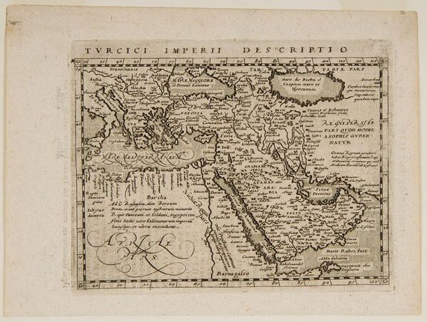
Kaart met de reizen van de apostelen Petrus en Paulus, met een plattegrond van Jeruzalem 1701 - 1736
0:00
0:00
anonymous
Rijksmuseum
drawing, print, paper, ink, engraving
#
drawing
#
narrative-art
#
baroque
# print
#
landscape
#
paper
#
ink
#
islamic-art
#
engraving
Dimensions: height 376 mm, width 533 mm
Copyright: Rijks Museum: Open Domain
Editor: This is a fascinating print from the early 18th century, "Map of the journeys of the apostles Peter and Paul, with a plan of Jerusalem," created anonymously, using engraving and ink on paper. It strikes me as quite detailed for its time, but also serves a clear didactic purpose. What do you make of this combination of artistry and religious instruction? Curator: This print embodies the intersection of religious authority, cartography, and the burgeoning public sphere of the early 18th century. These maps weren't just about geographical accuracy. They visualized and reinforced religious narratives, particularly within a context of increasing global awareness due to expanding trade and colonialism. Editor: So the map itself becomes a tool for solidifying religious beliefs? Curator: Precisely. Consider the power of seeing the journeys of these apostles laid out so definitively. It anchors the biblical narrative in a seemingly objective reality, lending credence and reinforcing its significance for viewers. Furthermore, the inclusion of Jerusalem highlights the symbolic centrality of the city to the Christian faith, serving as a potent visual reminder of its importance. Do you think the depiction of Jerusalem is realistic? Editor: It looks more like a symbolic representation. The overall impression is that it is carefully composed with that beautiful cartouche framed by the classical statues. Curator: And the baroque cartouche signals the prestige and authority associated with disseminating this visual information. What audience do you think it was aimed at? Was this meant to be something accessible? Editor: Well, given the detail and Latin inscriptions, probably a more educated segment of society, perhaps clergy or scholars? It's interesting how faith was disseminated using visual means for political, educational, and ideological purposes. Curator: Exactly. Understanding that dynamic unlocks a much deeper reading of the image beyond just its surface aesthetic qualities. It's an amazing example of the visual encoding of knowledge and faith. Editor: This was truly enlightening, thinking about maps in the early 18th century. It really broadened my understanding.
Comments
No comments
Be the first to comment and join the conversation on the ultimate creative platform.
More like this