print, engraving
#
dutch-golden-age
# print
#
geometric
#
engraving
Dimensions: height 797 mm, width 899 mm
Copyright: Rijks Museum: Open Domain
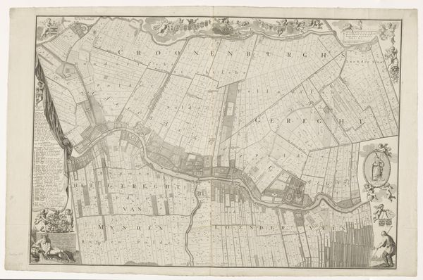
Curator: This print, entitled "Kaart van de Noordplaspolder," or "Map of the Noordplaspolder," dates from after 1767 and was made by T. Koning. It is an engraving depicting a section of reclaimed land in the Netherlands. Editor: My immediate reaction is one of geometrical precision and order. The map's strong lines create these repetitive rectangular shapes, making it all so neat. Curator: Indeed. The emphasis on geometric forms underscores the Dutch Golden Age preoccupation with order, control, and the mastery over the natural world. The very act of creating polders—draining and reclaiming land—speaks to this ambition, doesn't it? This map not only visualizes this human intervention but also functions as a document of property and ownership, essential to the societal structure and economy of the time. Editor: Right, and this print translates the complexity of the project onto a flat surface. Look how the linear structure creates an almost hypnotic grid. The text placements also act as interesting geometric markers, creating a structured hierarchy of visual information. I'm curious, though, about the registers to the left and right: do these serve a different purpose than the actual map? Curator: They do. Those are "registers of ambacht," essentially listings of landowners, with information on their holdings, which reflects social status and financial stability. These are not neutral depictions; they represent a certain social and economic structure. It is fascinating to understand how these maps helped the consolidation of wealth and power at the time. Editor: Absolutely. Considering its functionality as an information medium, what's striking to me is the map’s beauty, almost an artistic expression through careful engraving techniques. Look at the different line thicknesses which generate textures; its abstraction turns it almost into a work of minimalist art. Curator: Exactly. These visual strategies are key, not just in representing land, but also in how the community perceived it, shaping perceptions and legitimizing land control. Editor: In the end, it goes well beyond what its main subject seems to indicate: a landscape rendered on a flat surface. It's really a cultural artefact representing human agency, technology, and social organization. Curator: I agree. "Kaart van de Noordplaspolder" becomes an eloquent artifact, where lines, text, and space reflect how communities engage in profound transformations to adapt the territory to their own necessities, beliefs, and even dreams.
Comments
No comments
Be the first to comment and join the conversation on the ultimate creative platform.
More like this