About this artwork
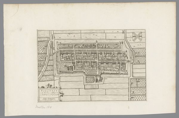
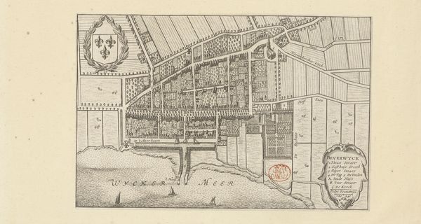
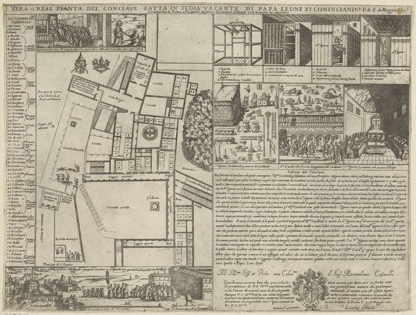
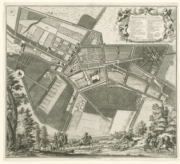
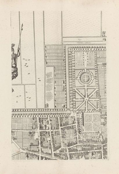
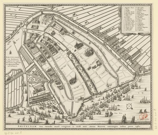
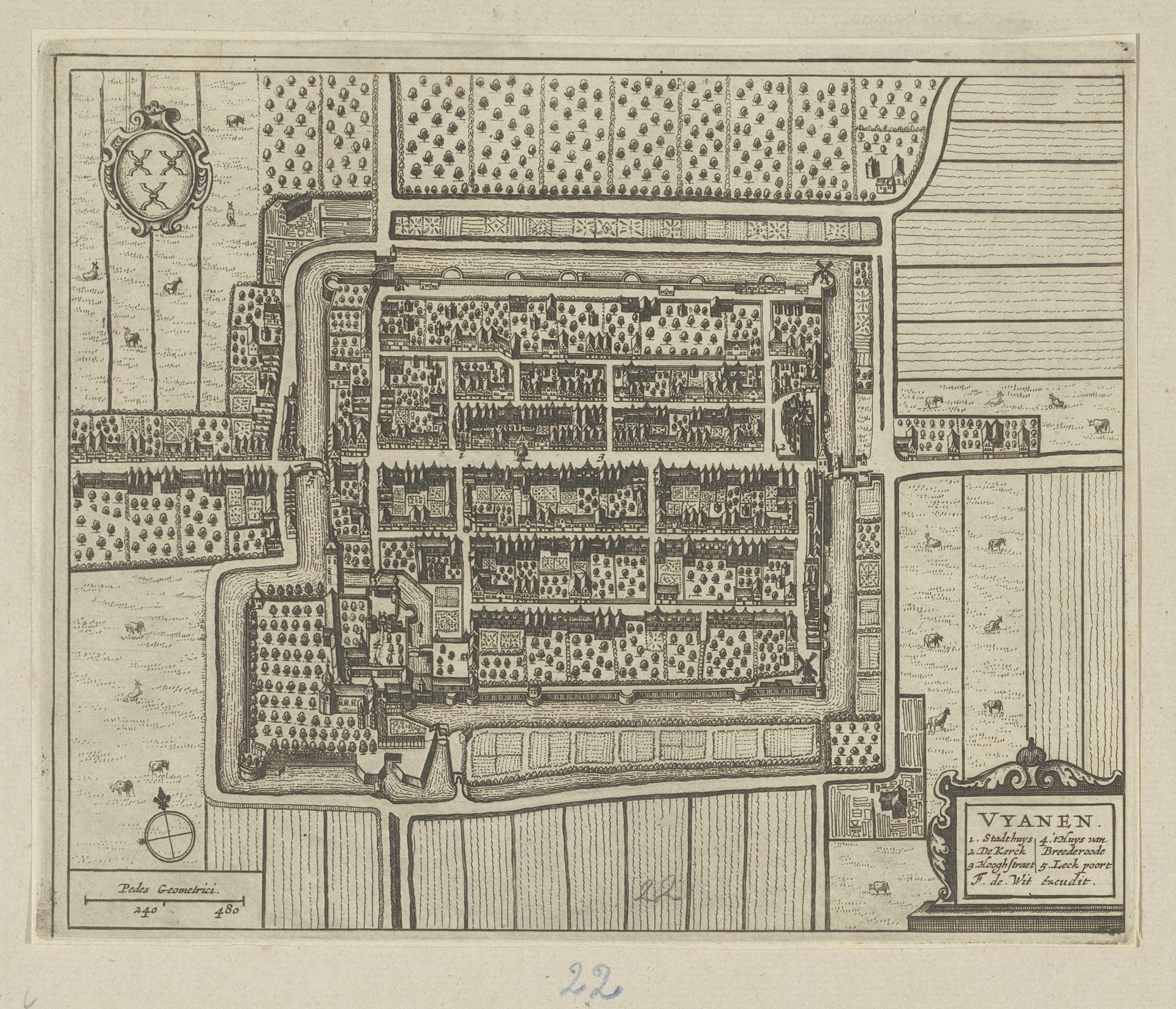
Curator: Looking at this detailed cityscape, my first thought is—it’s all so tidy! So ordered. Like a miniature world meticulously planned out. Editor: And you’re right to observe that sense of order. What we're seeing is a bird's-eye view, or floor plan, of Vianen, dating back to the Dutch Golden Age, circa 1657-1728. It’s currently held in the Rijksmuseum. What do you make of it? Curator: Well, it’s anonymous, for starters. The kind of controlled view here always makes me think about the power dynamics at play. Someone chose what to include, what to emphasize… like deciding which secrets to reveal, or what to simply ignore. The crisscrossing lines of the city… they're like veins, both connecting and containing the city’s heart. Editor: Precisely! Cities have long been centers of power, trade, and knowledge. In this instance, this isn't just an image; it represents urban planning, infrastructure, and, of course, governance. I love to consider the very deliberate creation of space within the bounds of society. This piece offers a structured landscape that is actually about trade and commerce. You notice that emphasis on fortification? Walls aren't just boundaries, they protect a city's trade routes! Curator: And the technique, this detailed engraving… it’s fascinating! Makes me think of poetry, how constraints force invention. Did the limitations actually help to spark artistic expression here? Editor: Well, thinking about its impact and relevance today is useful, too. In our world, there are so many different modes of mapping. What once was captured by hand with ink, now we can zoom in with drones. I like to consider how access to different ways of capturing an environment might contribute to new narratives and challenge old boundaries. Curator: Thinking about those narratives...this image does hint at unseen stories playing out in each little building. People falling in love, making bad decisions, experiencing joy or grief… Each life, in turn, shaping the whole. And I’m struck by the reminder of change—this world we’re seeing frozen in ink exists only in memory now. Editor: Ultimately, a work like this asks us to contemplate the many ways places shape lives, and how people shape places, constantly reimagining their environments to mirror and materialize social, political, and even artistic ambition. It is pretty interesting!
Artwork details
- Medium
- print, engraving
- Dimensions
- height 217 mm, width 264 mm
- Location
- Rijksmuseum
- Copyright
- Rijks Museum: Open Domain
Tags
Comments
Share your thoughts
About this artwork
Curator: Looking at this detailed cityscape, my first thought is—it’s all so tidy! So ordered. Like a miniature world meticulously planned out. Editor: And you’re right to observe that sense of order. What we're seeing is a bird's-eye view, or floor plan, of Vianen, dating back to the Dutch Golden Age, circa 1657-1728. It’s currently held in the Rijksmuseum. What do you make of it? Curator: Well, it’s anonymous, for starters. The kind of controlled view here always makes me think about the power dynamics at play. Someone chose what to include, what to emphasize… like deciding which secrets to reveal, or what to simply ignore. The crisscrossing lines of the city… they're like veins, both connecting and containing the city’s heart. Editor: Precisely! Cities have long been centers of power, trade, and knowledge. In this instance, this isn't just an image; it represents urban planning, infrastructure, and, of course, governance. I love to consider the very deliberate creation of space within the bounds of society. This piece offers a structured landscape that is actually about trade and commerce. You notice that emphasis on fortification? Walls aren't just boundaries, they protect a city's trade routes! Curator: And the technique, this detailed engraving… it’s fascinating! Makes me think of poetry, how constraints force invention. Did the limitations actually help to spark artistic expression here? Editor: Well, thinking about its impact and relevance today is useful, too. In our world, there are so many different modes of mapping. What once was captured by hand with ink, now we can zoom in with drones. I like to consider how access to different ways of capturing an environment might contribute to new narratives and challenge old boundaries. Curator: Thinking about those narratives...this image does hint at unseen stories playing out in each little building. People falling in love, making bad decisions, experiencing joy or grief… Each life, in turn, shaping the whole. And I’m struck by the reminder of change—this world we’re seeing frozen in ink exists only in memory now. Editor: Ultimately, a work like this asks us to contemplate the many ways places shape lives, and how people shape places, constantly reimagining their environments to mirror and materialize social, political, and even artistic ambition. It is pretty interesting!
Comments
Share your thoughts