drawing, print, etching, engraving
#
drawing
#
baroque
# print
#
etching
#
perspective
#
geometric
#
line
#
cityscape
#
italian-renaissance
#
engraving
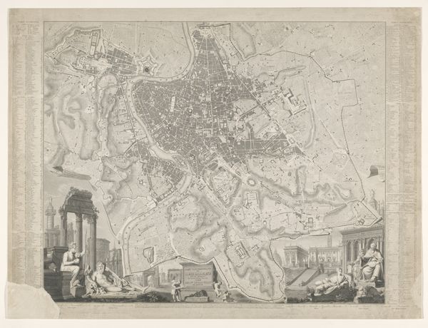
Dimensions: 65 5/8 × 79 7/8 in. (166.69 × 202.88 cm) (image)70 × 89 1/2 × 1 5/8 in. (177.8 × 227.33 × 4.13 cm) (including top mount and bottom roller)77 1/2 × 91 1/2 × 5 1/4 in. (196.85 × 232.41 × 13.34 cm) (outer frame)
Copyright: Public Domain
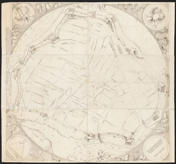
Curator: Wow, look at the density of that city—it almost breathes off the page, doesn't it? Editor: Indeed. We’re looking at Giovanni Battista Nolli’s “Plan of Rome,” created in 1748. It’s an engraving and etching, a meticulously detailed cityscape. Curator: Cityscape, yes, but it feels almost alive to me. Not just buildings and streets, but capturing Rome’s very spirit. You know, all that Baroque drama! Those converging lines just pull you in... like destiny. Editor: Quite right about the converging lines. Nolli employed precise, geometric perspectives. Note how public spaces are rendered as open, inviting areas, while private residences are starkly filled, an almost binary reading of societal life in the Eternal City. Curator: Binary—that’s cold. But the map itself… there’s a flow to it, almost like looking at veins, with everything connecting, leading you to something bigger. I mean, imagine Nolli wandering those streets himself. Must have been like feeling history pulse beneath his feet! Editor: One can speculate. Technically, however, we can appreciate Nolli’s use of line, its weight and consistency allowing for easy interpretation. This work serves as both a topographical record and a socio-spatial commentary via calculated arrangement. Curator: Haha! Socio-spatial commentary! I like that. A bit fancy for an old map maybe, but I get it! It’s more than just navigation—it's an invitation to lose yourself, you know? That beautiful, messy embrace of chaos and grandeur… you feel the human touch amidst all those tiny buildings. Editor: Undeniably, and one recognizes in this visual rhetoric a desire to impose order, which itself engages a subtle tension with the baroque dynamism you observed. It seems Nolli attempts mastery over Rome’s sprawling form through disciplined draftsmanship. Curator: Yes! Exactly! Control the chaos! Beautiful tension… Thanks, I'll feel it even more vividly next time I walk in Rome. Editor: As will I, perhaps newly sensitive to my attempt at rational mastery in interpreting this. Thank you for your insights.
Comments
minneapolisinstituteofart over 2 years ago
⋮
Conservation was generously funded by the Blackman-Helseth Foundation and Larry Oakey. Giovanni Battista Nolli's monumental New Plan of Rome is a landmark in cartography. The plan far outstripped its predecessors in terms of accuracy and detail. Rather than depicting a bird’s-eye view or artistic rendering of the city, Nolli, an engineer and architect, carefully executed an orthogonal map (a measured ground plan) based on over a decade of surveying the city. He had new measuring devices and a large team of assistants and surveyors at his disposal, not to mention papal support, which allowed him access to measure private properties as well as public. He did not rely on earlier models, as was the usual practice. Instead, he and his team started from scratch, thus the title of the work "Nuova pianta di Roma." This safeguarded their map from repeating errors. The scale of the project was immense—some 1,300 building are indexed on the map—and no detail was overlooked—every building measured, every road and fountain described. Nolli employed three engravers to execute the massive work, which is printed from twelve copper plates. The painter Stefano Pozzi designed the architectural vignettes and allegories in the foreground representing ancient Rome and modern Rome.
Join the conversation
Join millions of artists and users on Artera today and experience the ultimate creative platform.
More like this