About this artwork
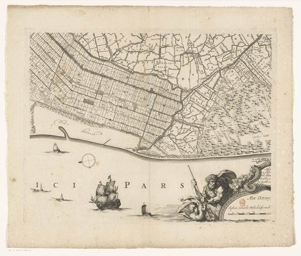
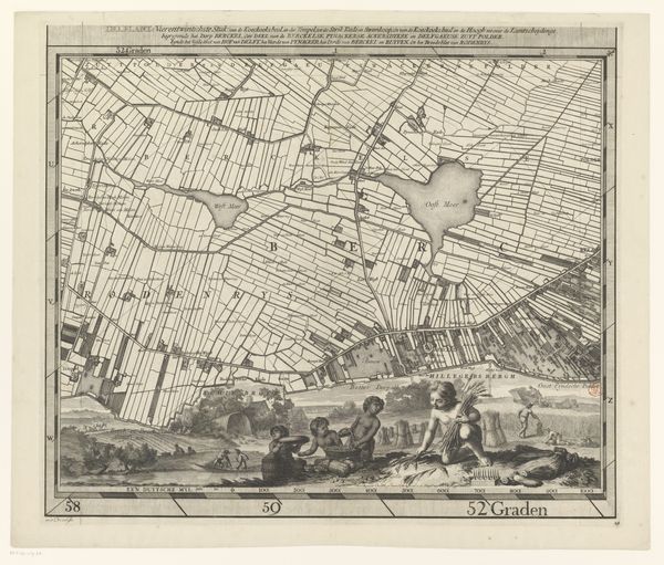
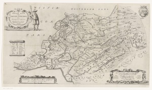
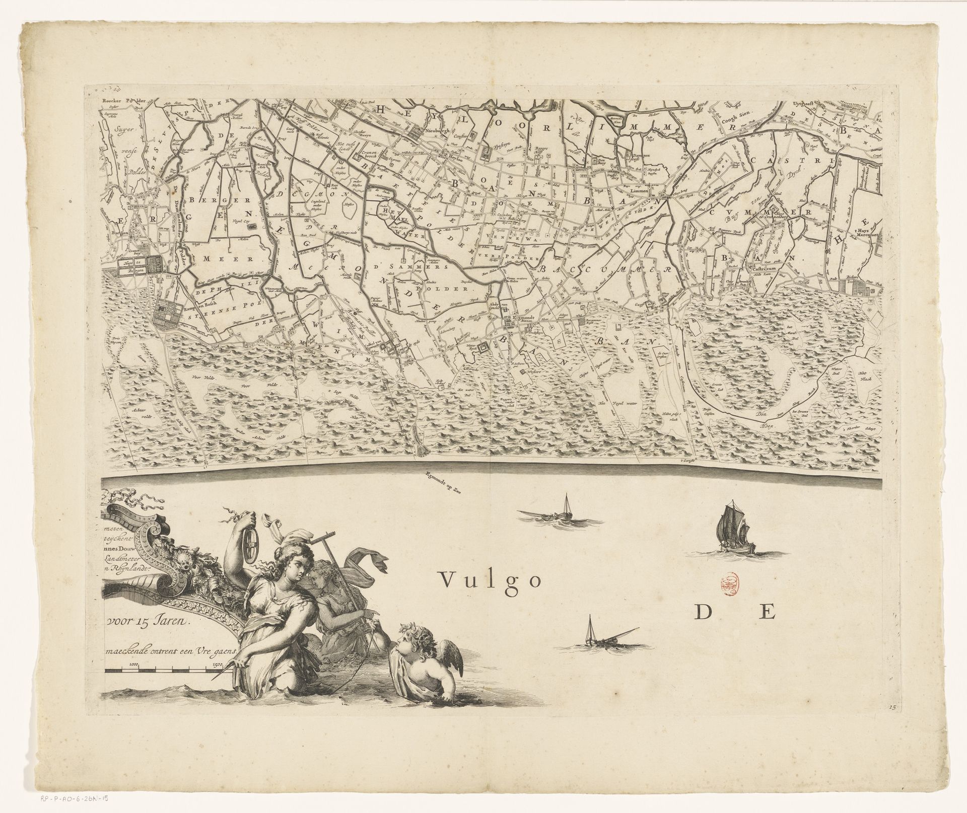
Curator: This is Coenraet Decker's "Kaart van Kennemerland en West-Friesland (vijftiende deel)," dating back to 1680. What strikes you about it initially? Editor: The overwhelming detail, all rendered by hand... It evokes a sense of painstaking labor. Makes me think of the workshops and apprentices who likely collaborated on such a complex project. The land meticulously depicted above the serene seascape, populated by allegorical figures – quite a contrast in styles! Curator: Absolutely. Decker’s rendering is quite intricate. It almost feels like I could wander through the depicted landscape and maybe stumble into one of those meticulously detailed farmhouses! It's amazing to think of the craftsmanship, particularly when viewed within the context of the Dutch Golden Age, when maps like these weren't just navigational tools, but assertions of knowledge and control. Editor: The Dutch were expanding their trade routes during the 17th century and global power required accurate cartography. Beyond the decorative elements, look at the printing technique here. Engraving on a copper plate required immense skill and was critical in reproducing precise lines, but even then, each print might show slight variations from the wear and tear on the plate. Every impression carries a story of production. Curator: I’m especially drawn to how Decker blends that technical accuracy with what almost feels like a dreamlike quality. The ornate flourishes feel so evocative of something much bigger. He brings a scientific exactitude together with an undeniable artistry. Do you think that speaks to a particular intent, on the part of the artist, do you suppose? Editor: I think it reflects a negotiation between the practical needs of his patrons – likely wealthy merchants or civic authorities – and a broader culture that celebrated visual display. Maps could be simultaneously functional, status symbols and tools for the statecraft. This engraving blurs these high/low categories. Curator: That friction adds an extra layer of depth. And somehow that is echoed by this map still speaking to us today; not as a precise navigational aid, perhaps, but as a guide to understanding ourselves and the ever-shifting ways we interact with our world. Editor: Yes, these lines etched in copper tell multiple interwoven stories, of land, power, and craft—they speak about a very specific time and place. They also have far-reaching relevance.
Kaart van Kennemerland en West-Friesland (vijftiende deel)
1680
Coenraet Decker
1650 - 1685Location
RijksmuseumArtwork details
- Medium
- graphic-art, print, engraving
- Dimensions
- height 454 mm, width 590 mm
- Location
- Rijksmuseum
- Copyright
- Rijks Museum: Open Domain
Tags
Comments
Share your thoughts
About this artwork
Curator: This is Coenraet Decker's "Kaart van Kennemerland en West-Friesland (vijftiende deel)," dating back to 1680. What strikes you about it initially? Editor: The overwhelming detail, all rendered by hand... It evokes a sense of painstaking labor. Makes me think of the workshops and apprentices who likely collaborated on such a complex project. The land meticulously depicted above the serene seascape, populated by allegorical figures – quite a contrast in styles! Curator: Absolutely. Decker’s rendering is quite intricate. It almost feels like I could wander through the depicted landscape and maybe stumble into one of those meticulously detailed farmhouses! It's amazing to think of the craftsmanship, particularly when viewed within the context of the Dutch Golden Age, when maps like these weren't just navigational tools, but assertions of knowledge and control. Editor: The Dutch were expanding their trade routes during the 17th century and global power required accurate cartography. Beyond the decorative elements, look at the printing technique here. Engraving on a copper plate required immense skill and was critical in reproducing precise lines, but even then, each print might show slight variations from the wear and tear on the plate. Every impression carries a story of production. Curator: I’m especially drawn to how Decker blends that technical accuracy with what almost feels like a dreamlike quality. The ornate flourishes feel so evocative of something much bigger. He brings a scientific exactitude together with an undeniable artistry. Do you think that speaks to a particular intent, on the part of the artist, do you suppose? Editor: I think it reflects a negotiation between the practical needs of his patrons – likely wealthy merchants or civic authorities – and a broader culture that celebrated visual display. Maps could be simultaneously functional, status symbols and tools for the statecraft. This engraving blurs these high/low categories. Curator: That friction adds an extra layer of depth. And somehow that is echoed by this map still speaking to us today; not as a precise navigational aid, perhaps, but as a guide to understanding ourselves and the ever-shifting ways we interact with our world. Editor: Yes, these lines etched in copper tell multiple interwoven stories, of land, power, and craft—they speak about a very specific time and place. They also have far-reaching relevance.
Comments
Share your thoughts