drawing, print, paper, ink, engraving
#
drawing
#
dutch-golden-age
#
mechanical pen drawing
# print
#
pen sketch
#
old engraving style
#
landscape
#
paper
#
personal sketchbook
#
ink
#
sketchwork
#
geometric
#
pen-ink sketch
#
pen work
#
sketchbook drawing
#
cityscape
#
storyboard and sketchbook work
#
engraving
#
realism
#
initial sketch
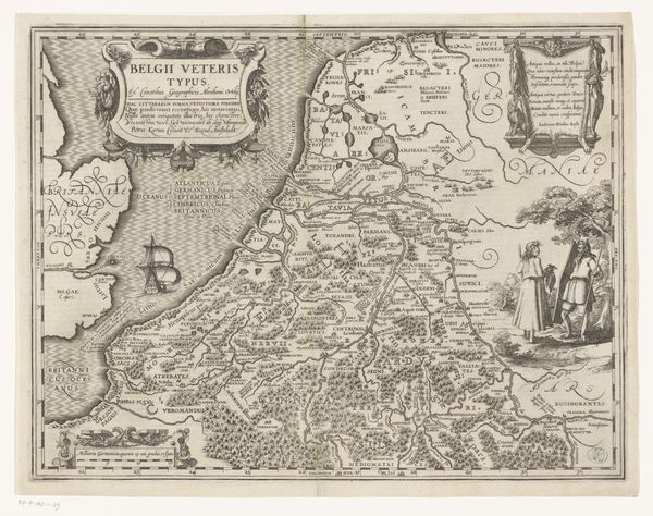
Dimensions: height 366 mm, width 662 mm
Copyright: Rijks Museum: Open Domain
This is Jacob van Meurs's map of Zevenwouden, etched in the 17th century, a canvas of cultural symbols and geographical precision. Note the figure of the farmer standing guard to the left of the map. Look at the spear, an archaic emblem, both of rural life and latent defense. The farmer's pose and the weapon he carries echo the classical figure of the watchful shepherd, a symbol of protection and order. It's a motif that carries us back to ancient pastoral scenes. The spear in the farmer's hand is a testament to cultural memory. It takes us to a deeper reflection on how symbols evolve through time. In ancient Greece, the spear was a symbol of power, defense, and war, held by gods and heroes alike. Over centuries, it has softened into an emblem of rural vigilance. The image resonates with both individual and collective identities. It taps into our subconscious associations, shaping our perceptions and emotional responses to the world around us.
Comments
No comments
Be the first to comment and join the conversation on the ultimate creative platform.
More like this