print, engraving
#
dutch-golden-age
# print
#
landscape
#
orientalism
#
engraving
Dimensions: height 374 mm, width 532 mm
Copyright: Rijks Museum: Open Domain
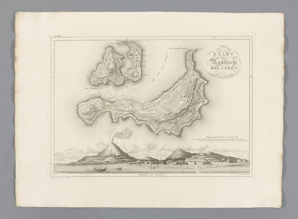
Curator: I find this 1818 print, titled "Kaart van de eilanden bij Noord-Molukken," which translates to "Map of the Islands near North Maluku," immediately striking. Produced by C. van Baarsel en Zoon, it offers an interesting perspective. Editor: It’s visually quite serene, almost delicate with its fine lines, yet the presence of that looming volcano gives it a potent undertone of potential volatility, a hidden danger beneath the beautiful archipelago. Curator: Absolutely. This landscape engraving, a product of the Dutch Golden Age infused with Orientalist perspectives, serves as a testament to Dutch colonial expansion. The visual details reveal the way cartography was used to lay claim to these territories and create power dynamics between the colonizer and colonized. Editor: Seeing it through an iconographic lens, I'm drawn to how maps themselves act as powerful symbols of control and knowledge. The depiction of the volcano, especially, taps into a primal sense of nature's force, almost mirroring the power dynamic you mentioned in the colonial context. Curator: Precisely, and the composition reinforces this tension. The carefully rendered islands suggest precision, ownership, and a scientific mindset while ignoring Indigenous systems of knowledge about how these spaces are negotiated and understood. The very act of naming is key to establishing the West's own worldview as fact. Editor: Yes, and thinking about that, it also strikes me how maps evolve into cultural artifacts over time. Today, we see the historic map itself as a relic representing not only a place but the mentality of a particular era, a loaded image with the history of colonialism built in. The careful execution carries weight—both aesthetic and ideological. Curator: The engraving medium adds another layer. Its precise, reproducible nature highlights a desire for standardization and control that runs parallel with the ambitions of colonial projects throughout history. Editor: It's like viewing a moment frozen in time, a testament to both human ingenuity and ambition, interwoven with underlying implications that affect our relationship with these islands even today. It’s a complicated history elegantly rendered in a deceptively simple-looking piece. Curator: It is, isn't it? Thinking about it, this map makes us reckon with the long-term repercussions of claiming land, and who decides which narrative takes precedence when examining those claims today.
Comments
No comments
Be the first to comment and join the conversation on the ultimate creative platform.
More like this